|
|
|
Specific Water Well Detail |
|
|
| Location Info | |||
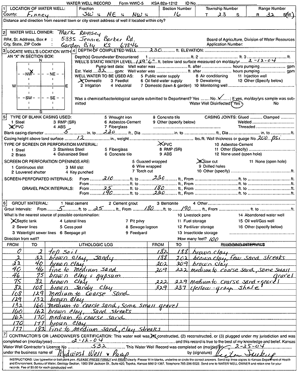
| Owner: Ramsey, Mark | Status: Constructed | ||
| Location: T23S, R32W, Sec. 16, SW NE NW | County: Finney | ||
| Directions: | |||
| Latitude: 38.0591289 | Longitude: -100.8413088 | Datum NAD 27 | |
| Latitude: 38.0591513 | Longitude: -100.8417457 | Datum NAD 83 | |
| Longitude and latitude calculated by Survey from township-range-section-quarter calls. Only good to within the quarter call accuracy. | |||
| View well on interactive map | |||
| General Info | ||
| Well Depth: 230 ft. | Elevation: ft. | |
| Static Water Level: 129.5 ft. | Est. Yield: 32 gpm. | |
| Comp. Date: 12-Feb-2004 | Well Use: Domestic | |
| DWR Applic. #: | Other ID: | |
| Driller Info | ||
| Driller: Midwest Well & Pump, Inc. | License #: 532 | |
| Scanned Form | View scan |
|
Chemical Sample Submitted?:
Water Well disinfected?: | ||
| Casing Info | ||
| Casing Type:
Casing Joints: |
Diam: in. to ft | |
| Casing height above land surface: in
Casing Weight: lbs/ft Wall thickness or gauge no.: | ||
| Screen and Perforation Info | ||
| Screen Type: | Screen Openings: | |
| Screen-perforated intervals | From: ft to ft | |
| Gravel pack intervals | From: ft to ft | |
| Grout Info | ||
| Grout used: | From: to ft | |
| Source of Possible Contamination | ||
| Source: | ||
| Direction from well: | Distance: ft | |
| Lithologic Log
(Log data entered by KGS.) | ||
| From: 0 ft. to 2 ft. | top soil | |
| From: 2 ft. to 22 ft. | brown clay, sandy | |
| From: 22 ft. to 40 ft. | brown clay | |
| From: 40 ft. to 46 ft. | fine to medium sand | |
| From: 46 ft. to 75 ft. | brown clay and gypsum | |
| From: 75 ft. to 82 ft. | brown clay | |
| From: 82 ft. to 108 ft. | brown sandy clay | |
| From: 108 ft. to 129 ft. | medium to coarse sand | |
| From: 129 ft. to 132 ft. | brown clay | |
| From: 132 ft. to 160 ft. | medium to coarse sand, some small gravel | |
| From: 160 ft. to 162 ft. | brown clay, sand streaks | |
| From: 162 ft. to 170 ft. | medium to coarse sand | |
| From: 170 ft. to 177 ft. | brown clay | |
| From: 177 ft. to 182 ft. | fine to medium sand, clay streaks | |
| From: 182 ft. to 188 ft. | brown clay | |
| From: 188 ft. to 202 ft. | brown clay, few sand streaks | |
| From: 202 ft. to 209 ft. | brown clay | |
| From: 209 ft. to 222 ft. | medium to coarse sand, some small gravel | |
| From: 222 ft. to 229 ft. | medium to coarse sand and gravel | |
| From: 229 ft. to 237 ft. | yellow - gray shale | |