|
|
|
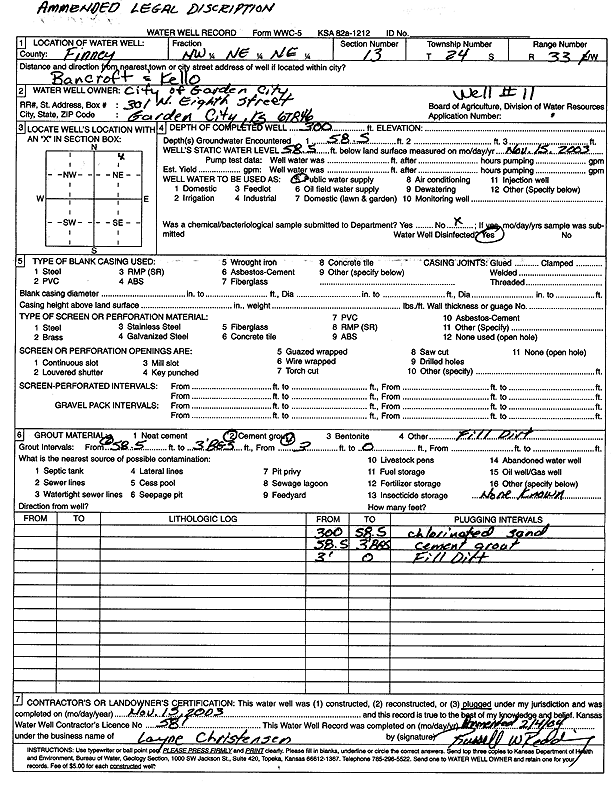
Specific Water Well Detail |
|
|
| Location Info | |||
| Owner: City of Garden City | Status: Constructed | ||
| Location: T24S, R33W, Sec. 13, NW NE NE | County: Finney | ||
| Directions: Bancroft and Kello | |||
| Latitude: 37.9740555 | Longitude: -100.8864269 | Datum NAD 27 | |
| Latitude: 37.9740787 | Longitude: -100.8868671 | Datum NAD 83 | |
| Longitude and latitude calculated by Survey from township-range-section-quarter calls. Only good to within the quarter call accuracy. | |||
| View well on interactive map | |||
| General Info | ||
| Well Depth: 300 ft. | Elevation: ft. | |
| Static Water Level: 58.5 ft. | Est. Yield: gpm. | |
| Comp. Date: 15-Nov-2003 | Well Use: Public Water Supply | |
| DWR Applic. #: | Other ID: well 11 | |
| Driller Info | ||
| Driller: Layne Western | License #: 581 | |
| Scanned Form | View scan |
|
Chemical Sample Submitted?:
Water Well disinfected?: | ||
| Casing Info | ||
| Casing Type:
Casing Joints: |
Diam: in. to ft | |
| Casing height above land surface: in
Casing Weight: lbs/ft Wall thickness or gauge no.: | ||
| Screen and Perforation Info | ||
| Screen Type: | Screen Openings: | |
| Screen-perforated intervals | From: ft to ft | |
| Gravel pack intervals | From: ft to ft | |
| Grout Info | ||
| Grout used: | From: to ft | |
| Source of Possible Contamination | ||
| Source: | ||
| Direction from well: | Distance: ft | |