|
|
|
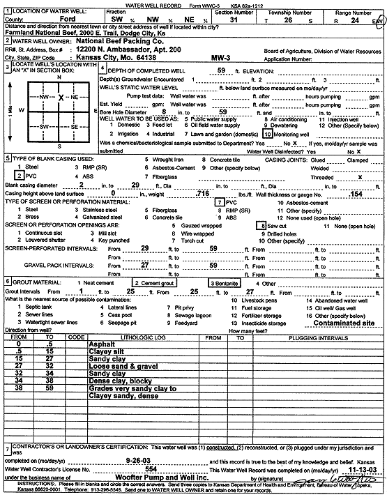
Specific Water Well Detail |
|
|
| Location Info | |||
| Owner: National Beef Packing Co. | Status: Constructed | ||
| Location: T26S, R24W, Sec. 31, SW NW NE | County: Ford | ||
| Directions: Farmland National Beef, 2000 E Trail, Dodge City | |||
| Latitude: 37.7479634 | Longitude: -99.9862426 | Datum NAD 27 | |
| Latitude: 37.7479837 | Longitude: -99.9866538 | Datum NAD 83 | |
| Longitude and latitude calculated by Survey from township-range-section-quarter calls. Only good to within the quarter call accuracy. | |||
| View well on interactive map | |||
| General Info | ||
| Well Depth: 59 ft. | Elevation: ft. | |
| Static Water Level: ft. | Est. Yield: gpm. | |
| Comp. Date: 26-Sep-2003 | Well Use: Monitoring well/observation/piezometer | |
| DWR Applic. #: | Other ID: MW 3 | |
| Driller Info | ||
| Driller: Jay C. Woofter Pump & Well, Inc. | License #: 554 | |
| Scanned Form | View scan |
|
Chemical Sample Submitted?:
Water Well disinfected?: | ||
| Casing Info | ||
| Casing Type:
Casing Joints: |
Diam: in. to ft | |
| Casing height above land surface: in
Casing Weight: lbs/ft Wall thickness or gauge no.: | ||
| Screen and Perforation Info | ||
| Screen Type: | Screen Openings: | |
| Screen-perforated intervals | From: ft to ft | |
| Gravel pack intervals | From: ft to ft | |
| Grout Info | ||
| Grout used: | From: to ft | |
| Source of Possible Contamination | ||
| Source: | ||
| Direction from well: | Distance: ft | |
| Lithologic Log
(Log data entered by KGS.) | ||
| From: 0 ft. to .5 ft. | asphalt | |
| From: .5 ft. to 15 ft. | clayey silt | |
| From: 15 ft. to 27 ft. | sandy clay | |
| From: 27 ft. to 32 ft. | loose sand and gravel | |
| From: 32 ft. to 34 ft. | sandy clay | |
| From: 34 ft. to 38 ft. | dense clay, blocky | |
| From: 38 ft. to 59 ft. | grades very sandy clay to clayey sandy, dense | |