|
|
|
Specific Water Well Detail |
|
|
| Location Info | |||
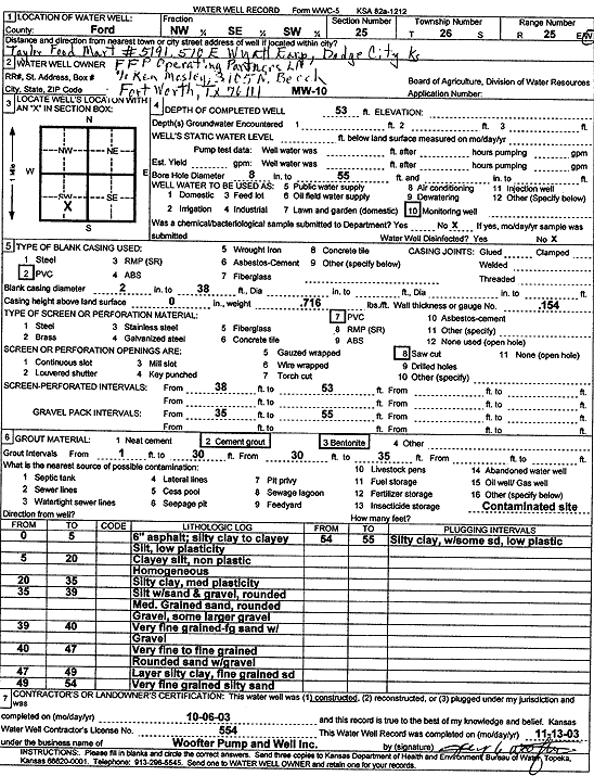
| Owner: FFP Operating Partners | Status: Constructed | ||
| Location: T26S, R25W, Sec. 25, NW SE SW | County: Ford | ||
| Directions: 510 E Wyatt Earp, Dodge City | |||
| Latitude: 37.753499 | Longitude: -100.0085788 | Datum NAD 27 | |
| Latitude: 37.7535193 | Longitude: -100.0089907 | Datum NAD 83 | |
| Longitude and latitude calculated by Survey from township-range-section-quarter calls. Only good to within the quarter call accuracy. | |||
| View well on interactive map | |||
| General Info | ||
| Well Depth: 53 ft. | Elevation: ft. | |
| Static Water Level: ft. | Est. Yield: gpm. | |
| Comp. Date: 06-Oct-2003 | Well Use: Monitoring well/observation/piezometer | |
| DWR Applic. #: | Other ID: MW 10 | |
| Driller Info | ||
| Driller: Jay C. Woofter Pump & Well, Inc. | License #: 554 | |
| Scanned Form | View scan |
|
Chemical Sample Submitted?:
Water Well disinfected?: | ||
| Casing Info | ||
| Casing Type:
Casing Joints: |
Diam: in. to ft | |
| Casing height above land surface: in
Casing Weight: lbs/ft Wall thickness or gauge no.: | ||
| Screen and Perforation Info | ||
| Screen Type: | Screen Openings: | |
| Screen-perforated intervals | From: ft to ft | |
| Gravel pack intervals | From: ft to ft | |
| Grout Info | ||
| Grout used: | From: to ft | |
| Source of Possible Contamination | ||
| Source: | ||
| Direction from well: | Distance: ft | |
| Lithologic Log
(Log data entered by KGS.) | ||
| From: 0 ft. to 5 ft. | asphalt, silty clay to clayey silt, low plasticity | |
| From: 5 ft. to 20 ft. | clayey silt, non plastic homogeneous | |
| From: 20 ft. to 35 ft. | silty clay, medium plasticity | |
| From: 35 ft. to 39 ft. | silt with sand and gravel, rounded medium grained sand, rounded gravel, some larger gravel | |
| From: 39 ft. to 40 ft. | very fine grained, fine grained sand with gravel | |
| From: 40 ft. to 47 ft. | very fine to fine grained rounded sand with gravel | |
| From: 47 ft. to 49 ft. | layer silty clay, fine grained sand | |
| From: 49 ft. to 54 ft. | very fine grained silty sand | |
| From: 54 ft. to 55 ft. | silty clay, with some sand, low plastic | |