|
|
|
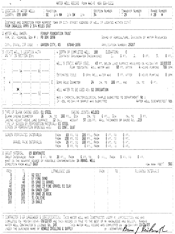
Specific Water Well Detail |
|
|
| Location Info | |||
| Owner: Finnup Foundation Trust | Status: Constructed | ||
| Location: T25S, R29W, Sec. 34, SE NW SW | County: Gray | ||
| Directions: from Ingalls: 2.75 mi E | |||
| Latitude: 37.8324513 | Longitude: -100.4975719 | Datum NAD 27 | |
| Latitude: 37.8324732 | Longitude: -100.4979994 | Datum NAD 83 | |
| Longitude and latitude calculated by Survey from township-range-section-quarter calls. Only good to within the quarter call accuracy. | |||
| View well on interactive map | |||
| General Info | ||
| Well Depth: 188 ft. | Elevation: ft. | |
| Static Water Level: 43 ft. | Est. Yield: gpm. | |
| Comp. Date: 22-Sep-2003 | Well Use: Irrigation | |
| DWR Applic. #: 25287 | Other ID: | |
| Links | |
| No Wizard information available. | |
| View info from WIMAS Water Right Data base... | |
| Driller Info | ||
| Driller: Richard Henkle Drilling & Supply Co. Inc. | License #: 145 | |
| Scanned Form | View scan |
|
Chemical Sample Submitted?:
Water Well disinfected?: | ||
| Casing Info | ||
| Casing Type:
Casing Joints: |
Diam: in. to ft | |
| Casing height above land surface: in
Casing Weight: lbs/ft Wall thickness or gauge no.: | ||
| Screen and Perforation Info | ||
| Screen Type: | Screen Openings: | |
| Screen-perforated intervals | From: ft to ft | |
| Gravel pack intervals | From: ft to ft | |
| Grout Info | ||
| Grout used: | From: to ft | |
| Source of Possible Contamination | ||
| Source: | ||
| Direction from well: | Distance: ft | |
| Lithologic Log
(Log data entered by KGS.) | ||
| From: 0 ft. to 2 ft. | SILT | |
| From: 2 ft. to 12 ft. | FINE SAND | |
| From: 12 ft. to 40 ft. | SAND GRAVEL | |
| From: 40 ft. to 109 ft. | SAND FINE GRAVEL CLAY | |
| From: 109 ft. to 138 ft. | SANDY CLAY | |
| From: 138 ft. to 163 ft. | SAND ROCK | |
| From: 163 ft. to 165 ft. | CALICHE | |
| From: 165 ft. to 172 ft. | SHALE | |