|
|
|
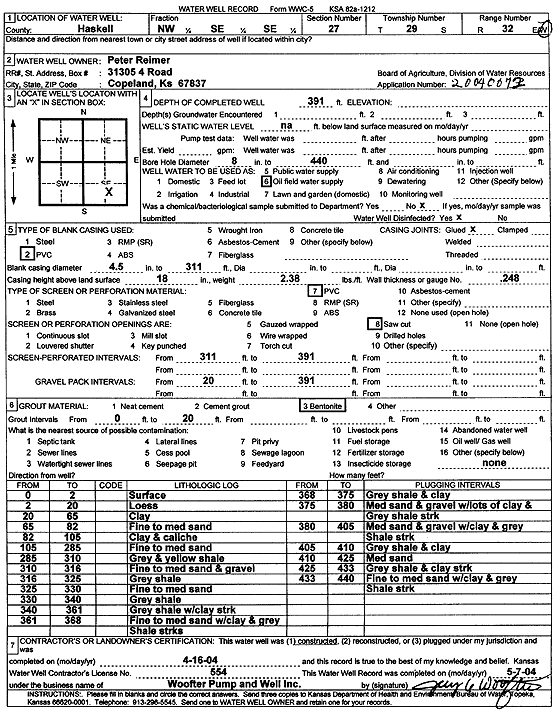
Specific Water Well Detail |
|
|
| Location Info | |||
| Owner: Reimer, Peter | Status: Constructed | ||
| Location: T29S, R32W, Sec. 27, NW SE SE | County: Haskell | ||
| Directions: | |||
| Latitude: 37.4921741 | Longitude: -100.8013823 | Datum NAD 27 | |
| Latitude: 37.4921986 | Longitude: -100.8018213 | Datum NAD 83 | |
| Longitude and latitude calculated by Survey from township-range-section-quarter calls. Only good to within the quarter call accuracy. | |||
| View well on interactive map | |||
| General Info | ||
| Well Depth: 391 ft. | Elevation: ft. | |
| Static Water Level: ft. | Est. Yield: gpm. | |
| Comp. Date: 16-Apr-2004 | Well Use: Oil Field Water Supply | |
| DWR Applic. #: 20040072 | Other ID: | |
| Links | |
| No Wizard information available. | |
| View info from WIMAS Water Right Data base... | |
| Driller Info | ||
| Driller: Jay C. Woofter Pump & Well, Inc. | License #: 554 | |
| Scanned Form | View scan |
|
Chemical Sample Submitted?:
Water Well disinfected?: | ||
| Casing Info | ||
| Casing Type:
Casing Joints: |
Diam: in. to ft | |
| Casing height above land surface: in
Casing Weight: lbs/ft Wall thickness or gauge no.: | ||
| Screen and Perforation Info | ||
| Screen Type: | Screen Openings: | |
| Screen-perforated intervals | From: ft to ft | |
| Gravel pack intervals | From: ft to ft | |
| Grout Info | ||
| Grout used: | From: to ft | |
| Source of Possible Contamination | ||
| Source: | ||
| Direction from well: | Distance: ft | |
| Lithologic Log
(Log data entered by KGS.) | ||
| From: 0 ft. to 2 ft. | surface | |
| From: 2 ft. to 20 ft. | loess | |
| From: 20 ft. to 65 ft. | clay | |
| From: 65 ft. to 82 ft. | fine to medium sand | |
| From: 82 ft. to 105 ft. | clay and caliche | |
| From: 105 ft. to 285 ft. | fine to medium sand | |
| From: 285 ft. to 310 ft. | gray and yellow shale | |
| From: 310 ft. to 316 ft. | fine to medium sand and gravel | |
| From: 316 ft. to 325 ft. | gray shale | |
| From: 325 ft. to 330 ft. | fine to medium sand | |
| From: 330 ft. to 340 ft. | gray shale | |
| From: 340 ft. to 361 ft. | gray shale with clay strk | |
| From: 361 ft. to 368 ft. | fine to medium sand with clay and gray shale streaks | |
| From: 368 ft. to 375 ft. | gray shale and clay | |
| From: 375 ft. to 380 ft. | medium sand and gravel with lots of clay and gray shale strk | |
| From: 380 ft. to 405 ft. | medium sand and gravel with clay and gray shale strk | |
| From: 405 ft. to 410 ft. | gray shale and clay | |
| From: 410 ft. to 425 ft. | medium sand | |
| From: 425 ft. to 433 ft. | gray shale and clay strk | |
| From: 433 ft. to 440 ft. | fine to medium sand with clay and gray shale strk | |