|
|
|
Specific Water Well Detail |
|
|
| Location Info | |||
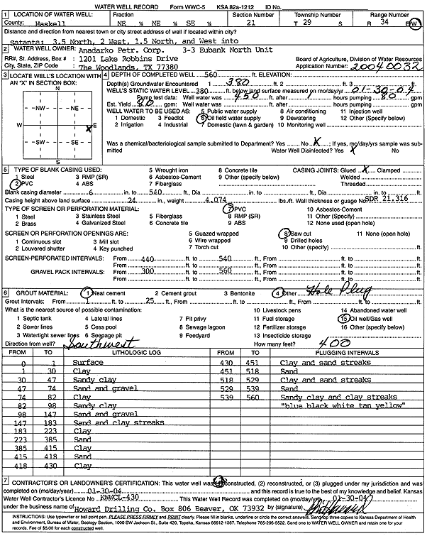
| Owner: Anadarko Petroleum Corp. | Status: Constructed | ||
| Location: T29S, R34W, Sec. 21, NE NE SE | County: Haskell | ||
| Directions: from Satanta: 3.5 mi N, 2 mi W, 1.5 mi N, W into site | |||
| Latitude: 37.5102795 | Longitude: -101.0356441 | Datum NAD 27 | |
| Latitude: 37.510304 | Longitude: -101.0360903 | Datum NAD 83 | |
| Longitude and latitude calculated by Survey from township-range-section-quarter calls. Only good to within the quarter call accuracy. | |||
| View well on interactive map | |||
| General Info | ||
| Well Depth: 560 ft. | Elevation: ft. | |
| Static Water Level: 380 ft. | Est. Yield: 80 gpm. | |
| Comp. Date: 30-Jan-2004 | Well Use: Oil Field Water Supply | |
| DWR Applic. #: 20040032 | Other ID: 3-3 Eubank Unit North | |
| Links | |
| No Wizard information available. | |
| View info from WIMAS Water Right Data base... | |
| Driller Info | ||
| Driller: Howard Drilling Company AG, LLC | License #: 430 | |
| Scanned Form | View scan |
|
Chemical Sample Submitted?:
Water Well disinfected?: | ||
| Casing Info | ||
| Casing Type:
Casing Joints: |
Diam: in. to ft | |
| Casing height above land surface: in
Casing Weight: lbs/ft Wall thickness or gauge no.: | ||
| Screen and Perforation Info | ||
| Screen Type: | Screen Openings: | |
| Screen-perforated intervals | From: ft to ft | |
| Gravel pack intervals | From: ft to ft | |
| Grout Info | ||
| Grout used: | From: to ft | |
| Source of Possible Contamination | ||
| Source: | ||
| Direction from well: | Distance: ft | |
| Lithologic Log
(Log data entered by KGS.) | ||
| From: 0 ft. to 1 ft. | surface | |
| From: 1 ft. to 30 ft. | clay | |
| From: 30 ft. to 47 ft. | sandy clay | |
| From: 47 ft. to 74 ft. | sand and gravel | |
| From: 74 ft. to 82 ft. | clay | |
| From: 82 ft. to 98 ft. | sandy clay | |
| From: 98 ft. to 147 ft. | sand and gravel | |
| From: 147 ft. to 183 ft. | sand and clay streaks | |
| From: 183 ft. to 223 ft. | clay | |
| From: 223 ft. to 385 ft. | sand | |
| From: 385 ft. to 415 ft. | clay | |
| From: 415 ft. to 418 ft. | sand | |
| From: 418 ft. to 430 ft. | clay | |
| From: 430 ft. to 451 ft. | clay and sand streaks | |
| From: 451 ft. to 518 ft. | sand | |
| From: 518 ft. to 529 ft. | clay and sand streaks | |
| From: 529 ft. to 539 ft. | sand | |
| From: 539 ft. to 560 ft. | sandy clay and clay streaks, blue, black, white, tan, yellow | |