|
|
|
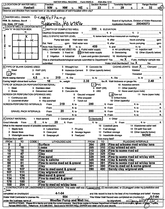
Specific Water Well Detail |
|
|
| Location Info | |||
| Owner: Hefkamp, George | Status: Constructed | ||
| Location: T29S, R32W, Sec. 23, NW NW NE | County: Haskell | ||
| Directions: | |||
| Latitude: 37.5176141 | Longitude: -100.7875134 | Datum NAD 27 | |
| Latitude: 37.5176388 | Longitude: -100.787952 | Datum NAD 83 | |
| Longitude and latitude calculated by Survey from township-range-section-quarter calls. Only good to within the quarter call accuracy. | |||
| View well on interactive map | |||
| General Info | ||
| Well Depth: 390 ft. | Elevation: ft. | |
| Static Water Level: ft. | Est. Yield: gpm. | |
| Comp. Date: 01-Apr-2004 | Well Use: Oil Field Water Supply | |
| DWR Applic. #: 20040073 | Other ID: | |
| Links | |
| No Wizard information available. | |
| View info from WIMAS Water Right Data base... | |
| Driller Info | ||
| Driller: Jay C. Woofter Pump & Well, Inc. | License #: 554 | |
| Scanned Form | View scan |
|
Chemical Sample Submitted?:
Water Well disinfected?: | ||
| Casing Info | ||
| Casing Type:
Casing Joints: |
Diam: in. to ft | |
| Casing height above land surface: in
Casing Weight: lbs/ft Wall thickness or gauge no.: | ||
| Screen and Perforation Info | ||
| Screen Type: | Screen Openings: | |
| Screen-perforated intervals | From: ft to ft | |
| Gravel pack intervals | From: ft to ft | |
| Grout Info | ||
| Grout used: | From: to ft | |
| Source of Possible Contamination | ||
| Source: | ||
| Direction from well: | Distance: ft | |
| Lithologic Log
(Log data entered by KGS.) | ||
| From: 0 ft. to 2 ft. | surface | |
| From: 2 ft. to 10 ft. | loess | |
| From: 10 ft. to 15 ft. | fine sand | |
| From: 15 ft. to 47 ft. | clay | |
| From: 47 ft. to 52 ft. | fine sand | |
| From: 52 ft. to 60 ft. | clay and caliche | |
| From: 60 ft. to 81 ft. | fine to some medium sand and gravel | |
| From: 81 ft. to 95 ft. | clay | |
| From: 95 ft. to 107 ft. | fine to medium sand and gravel | |
| From: 107 ft. to 111 ft. | clay with gravel streak | |
| From: 111 ft. to 134 ft. | medium sand and gravel | |
| From: 134 ft. to 178 ft. | fine to medium sand and gravel | |
| From: 178 ft. to 185 ft. | clay | |
| From: 185 ft. to 264 ft. | fine to medium sand with clay lens | |
| From: 264 ft. to 285 ft. | fine sand with some medium with clay lens | |
| From: 285 ft. to 310 ft. | clay with medium sand streak | |
| From: 310 ft. to 324 ft. | fine to some med sand | |
| From: 324 ft. to 329 ft. | clay | |
| From: 329 ft. to 345 ft. | fine to some medium sand with clay streak | |
| From: 345 ft. to 364 ft. | clay and sandy clay | |
| From: 364 ft. to 381 ft. | fine to some medium sand with clay lens | |
| From: 381 ft. to 390 ft. | fine to medium sand and some gravel | |
| From: 390 ft. to 400 ft. | sandy clay with gravel streak | |