|
|
|
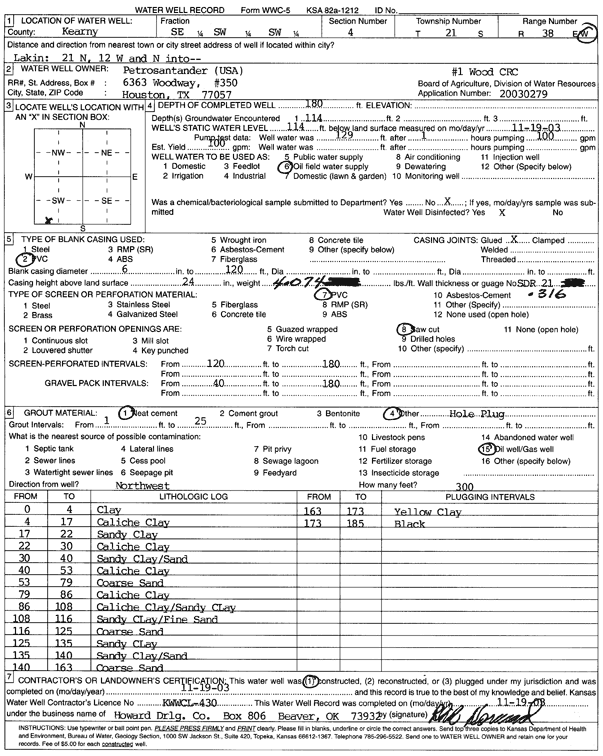
Specific Water Well Detail |
|
|
| Location Info | |||
| Owner: Petrosander USA | Status: Constructed | ||
| Location: T21S, R38W, Sec. 4, SE SW SW | County: Kearny | ||
| Directions: from Lakin: 21 mi N, 12 mi W, N into site | |||
| Latitude: 38.2498769 | Longitude: -101.5022455 | Datum NAD 27 | |
| Latitude: 38.2498946 | Longitude: -101.5026894 | Datum NAD 83 | |
| Longitude and latitude calculated by Survey from township-range-section-quarter calls. Only good to within the quarter call accuracy. | |||
| View well on interactive map | |||
| General Info | ||
| Well Depth: 180 ft. | Elevation: ft. | |
| Static Water Level: 114 ft. | Est. Yield: 100 gpm. | |
| Comp. Date: 19-Nov-2003 | Well Use: Oil Field Water Supply | |
| DWR Applic. #: 20030279 | Other ID: 1 Wood CRC | |
| Links | |
| No Wizard information available. | |
| View info from WIMAS Water Right Data base... | |
| Driller Info | ||
| Driller: Howard Drilling Company AG, LLC | License #: 430 | |
| Scanned Form | View scan |
|
Chemical Sample Submitted?:
Water Well disinfected?: | ||
| Casing Info | ||
| Casing Type:
Casing Joints: |
Diam: in. to ft | |
| Casing height above land surface: in
Casing Weight: lbs/ft Wall thickness or gauge no.: | ||
| Screen and Perforation Info | ||
| Screen Type: | Screen Openings: | |
| Screen-perforated intervals | From: ft to ft | |
| Gravel pack intervals | From: ft to ft | |
| Grout Info | ||
| Grout used: | From: to ft | |
| Source of Possible Contamination | ||
| Source: | ||
| Direction from well: | Distance: ft | |
| Lithologic Log
(Log data entered by KGS.) | ||
| From: 0 ft. to 4 ft. | clay | |
| From: 4 ft. to 17 ft. | caliche clay | |
| From: 17 ft. to 22 ft. | sandy clay | |
| From: 22 ft. to 30 ft. | caliche clay | |
| From: 30 ft. to 40 ft. | sandy clay/sand | |
| From: 40 ft. to 53 ft. | caliche clay | |
| From: 53 ft. to 79 ft. | coarse sand | |
| From: 79 ft. to 86 ft. | caliche clay | |
| From: 86 ft. to 108 ft. | caliche clay/sandy clay | |
| From: 108 ft. to 116 ft. | sandy clay/fine sand | |
| From: 116 ft. to 125 ft. | coarse sand | |
| From: 125 ft. to 135 ft. | sandy clay | |
| From: 135 ft. to 140 ft. | sandy clay/sand | |
| From: 140 ft. to 163 ft. | coarse sand | |
| From: 163 ft. to 173 ft. | yellow clay | |
| From: 179 ft. to 185 ft. | black | |