|
|
|
Specific Water Well Detail |
|
|
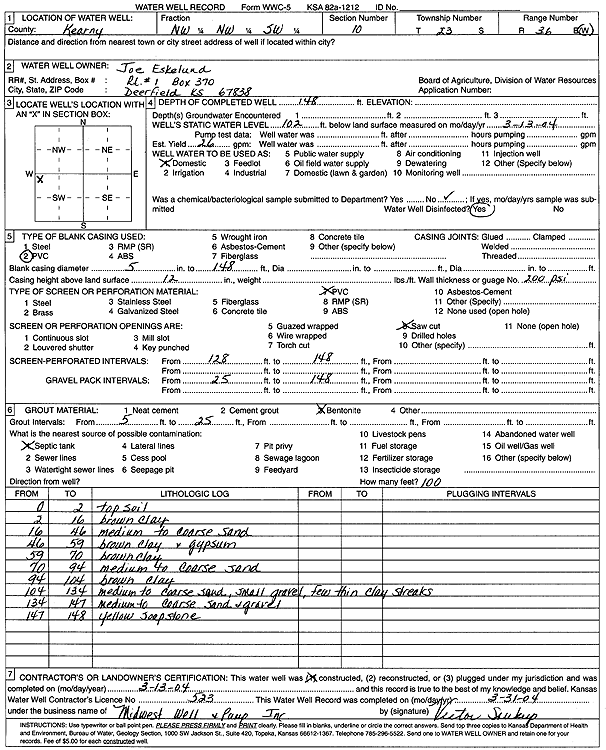
| Location Info | |||
| Owner: Eskelund, Joe | Status: Constructed | ||
| Location: T23S, R36W, Sec. 10, NW NW SW | County: Kearny | ||
| Directions: | |||
| Latitude: 38.0671893 | Longitude: -101.2657039 | Datum NAD 27 | |
| Latitude: 38.0672094 | Longitude: -101.2661493 | Datum NAD 83 | |
| Longitude and latitude calculated by Survey from township-range-section-quarter calls. Only good to within the quarter call accuracy. | |||
| View well on interactive map | |||
| General Info | ||
| Well Depth: 148 ft. | Elevation: ft. | |
| Static Water Level: 102 ft. | Est. Yield: 26 gpm. | |
| Comp. Date: 13-Mar-2004 | Well Use: Domestic | |
| DWR Applic. #: | Other ID: | |
| Driller Info | ||
| Driller: M & D Well Service | License #: 523 | |
| Scanned Form | View scan |
|
Chemical Sample Submitted?:
Water Well disinfected?: | ||
| Casing Info | ||
| Casing Type:
Casing Joints: |
Diam: in. to ft | |
| Casing height above land surface: in
Casing Weight: lbs/ft Wall thickness or gauge no.: | ||
| Screen and Perforation Info | ||
| Screen Type: | Screen Openings: | |
| Screen-perforated intervals | From: ft to ft | |
| Gravel pack intervals | From: ft to ft | |
| Grout Info | ||
| Grout used: | From: to ft | |
| Source of Possible Contamination | ||
| Source: | ||
| Direction from well: | Distance: ft | |
| Lithologic Log
(Log data entered by KGS.) | ||
| From: 0 ft. to 2 ft. | topsoil | |
| From: 2 ft. to 16 ft. | brown clay | |
| From: 16 ft. to 46 ft. | medium to coarse sand | |
| From: 46 ft. to 59 ft. | brown clay and gypsum | |
| From: 59 ft. to 70 ft. | brown clay | |
| From: 70 ft. to 94 ft. | medium to coarse sand | |
| From: 94 ft. to 104 ft. | brown clay | |
| From: 104 ft. to 134 ft. | medium to coarse sand, small gravel, few thin clay streaks | |
| From: 134 ft. to 147 ft. | medium to coarse sand and gravel | |
| From: 147 ft. to 148 ft. | yellow soapstone | |