|
|
|
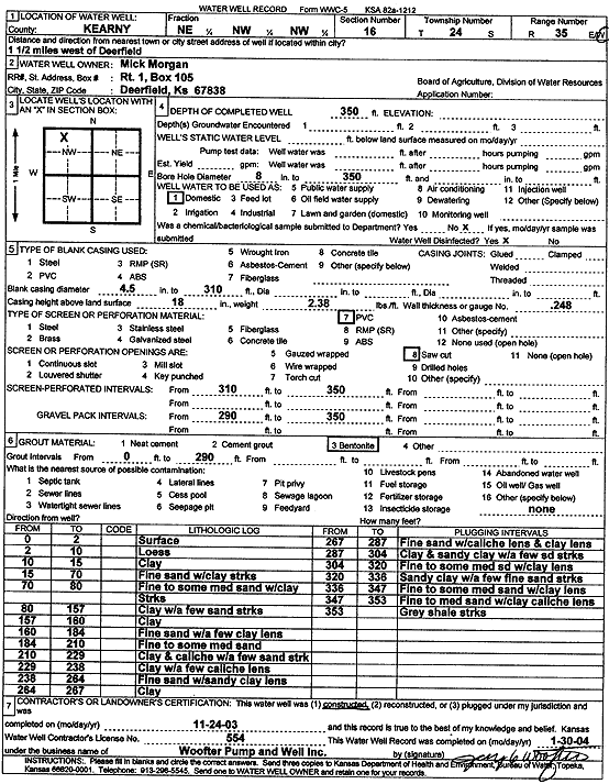
Specific Water Well Detail |
|
|
| Location Info | |||
| Owner: Morgan, Mick | Status: Constructed | ||
| Location: T24S, R35W, Sec. 16, NE NW NW | County: Kearny | ||
| Directions: from Deerfield: 1.5 mi W | |||
| Latitude: 37.9727528 | Longitude: -101.1723134 | Datum NAD 27 | |
| Latitude: 37.9727741 | Longitude: -101.1727599 | Datum NAD 83 | |
| Longitude and latitude calculated by Survey from township-range-section-quarter calls. Only good to within the quarter call accuracy. | |||
| View well on interactive map | |||
| General Info | ||
| Well Depth: 350 ft. | Elevation: ft. | |
| Static Water Level: ft. | Est. Yield: gpm. | |
| Comp. Date: 24-Nov-2003 | Well Use: Domestic | |
| DWR Applic. #: | Other ID: | |
| Driller Info | ||
| Driller: Jay C. Woofter Pump & Well, Inc. | License #: 554 | |
| Scanned Form | View scan |
|
Chemical Sample Submitted?:
Water Well disinfected?: | ||
| Casing Info | ||
| Casing Type:
Casing Joints: |
Diam: in. to ft | |
| Casing height above land surface: in
Casing Weight: lbs/ft Wall thickness or gauge no.: | ||
| Screen and Perforation Info | ||
| Screen Type: | Screen Openings: | |
| Screen-perforated intervals | From: ft to ft | |
| Gravel pack intervals | From: ft to ft | |
| Grout Info | ||
| Grout used: | From: to ft | |
| Source of Possible Contamination | ||
| Source: | ||
| Direction from well: | Distance: ft | |
| Lithologic Log
(Log data entered by KGS.) | ||
| From: 0 ft. to 2 ft. | surface | |
| From: 2 ft. to 10 ft. | loess | |
| From: 10 ft. to 15 ft. | clay | |
| From: 15 ft. to 70 ft. | fine sand with clay streaks | |
| From: 70 ft. to 80 ft. | fine to some medium sand with clay streaks | |
| From: 80 ft. to 157 ft. | clay with a few sand streaks | |
| From: 157 ft. to 160 ft. | clay | |
| From: 160 ft. to 184 ft. | fine sand with a few clay lens | |
| From: 184 ft. to 210 ft. | fine to some medium sand | |
| From: 210 ft. to 229 ft. | clay and caliche with a few sand streaks | |
| From: 229 ft. to 238 ft. | clay with a few caliche lens | |
| From: 238 ft. to 264 ft. | fine sand with sandy clay lens | |
| From: 264 ft. to 267 ft. | clay | |
| From: 267 ft. to 287 ft. | fine sand with caliche lens and clay lens | |
| From: 287 ft. to 304 ft. | clay and sandy clay with a few sand streaks | |
| From: 304 ft. to 320 ft. | fine to some medium sand with clay lens | |
| From: 320 ft. to 336 ft. | sandy clay with a few fine sand streaks | |
| From: 336 ft. to 347 ft. | fine to some medium sand with clay lens | |
| From: 347 ft. to 353 ft. | fine to medium sand with clay caliche lens | |
| From: 353 ft. to ft. | gray shale streaks | |