|
|
|
Specific Water Well Detail |
|
|
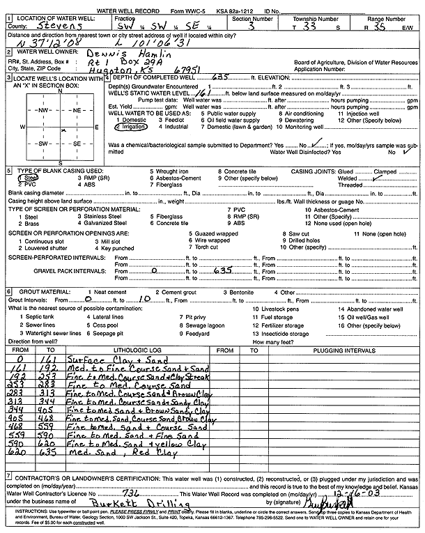
| Location Info | |||
| Owner: Hamlin, Dennis | Status: Constructed | ||
| Location: T33S, R35W, Sec. 3, SW SW SE | County: Stevens | ||
| Directions: | |||
| Latitude: 37.2021967 | Longitude: -101.1081677 | Datum NAD 27 | |
| Latitude: 37.202222 | Longitude: -101.108611 | Datum NAD 83 | |
| Longitude and latitude from GPS measurements. | |||
| GPS Latitude: 37.202222 | GPS Longitude: -101.108611 | Datum WGS84 | |
| View well on interactive map | |||
| General Info | ||
| Well Depth: 635 ft. | Elevation: ft. | |
| Static Water Level: 161 ft. | Est. Yield: gpm. | |
| Comp. Date: 01-Oct-2003 | Well Use: Irrigation | |
| DWR Applic. #: | Other ID: | |
| Links | |
| No Wizard information available. | |
| View info from WIMAS Water Right Data base... | |
| Driller Info | ||
| Driller: Burkett Drilling | License #: 736 | |
| Scanned Form | View scan |
|
Chemical Sample Submitted?:
Water Well disinfected?: | ||
| Casing Info | ||
| Casing Type:
Casing Joints: |
Diam: in. to ft | |
| Casing height above land surface: in
Casing Weight: lbs/ft Wall thickness or gauge no.: | ||
| Screen and Perforation Info | ||
| Screen Type: | Screen Openings: | |
| Screen-perforated intervals | From: ft to ft | |
| Gravel pack intervals | From: ft to ft | |
| Grout Info | ||
| Grout used: | From: to ft | |
| Source of Possible Contamination | ||
| Source: | ||
| Direction from well: | Distance: ft | |
| Lithologic Log
(Log data entered by KGS.) | ||
| From: 0 ft. to 161 ft. | surface clay and sand | |
| From: 161 ft. to 192 ft. | med to fine coarse sand and sand | |
| From: 192 ft. to 253 ft. | fine to med. coarse sand and clay streak | |
| From: 253 ft. to 283 ft. | fine to med. coarse sand | |
| From: 283 ft. to 313 ft. | fine to med. coarse sand and brown clay | |
| From: 313 ft. to 344 ft. | fine to med. coarse sand and sandy clay | |
| From: 344 ft. to 405 ft. | fine to medium sand and brown sandy clay | |
| From: 405 ft. to 468 ft. | fine to medium sand, coarse sand, brown clay | |
| From: 468 ft. to 559 ft. | fine to medium sand and coarse sand | |
| From: 559 ft. to 590 ft. | fine to medium sand and fine sand | |
| From: 590 ft. to 620 ft. | fine to medium sand and yellow clay | |
| From: 620 ft. to 635 ft. | medium sand, red clay | |