|
|
|
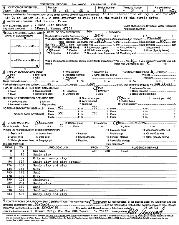
Specific Water Well Detail |
|
|
| Location Info | |||
| Owner: Nick Hatcher farms | Status: Constructed | ||
| Location: T34S, R35W, Sec. 23, SE SE SE | County: Stevens | ||
| Directions: from Hwy 83 and Tucker Rd: 9 mi W on Tucker Rd, N and W into driveway | |||
| Latitude: 37.0692912 | Longitude: -101.0857951 | Datum NAD 27 | |
| Latitude: 37.069317 | Longitude: -101.0862384 | Datum NAD 83 | |
| Longitude and latitude calculated by Survey from township-range-section-quarter calls. Only good to within the quarter call accuracy. | |||
| View well on interactive map | |||
| General Info | ||
| Well Depth: 700 ft. | Elevation: ft. | |
| Static Water Level: 206 ft. | Est. Yield: 80 gpm. | |
| Comp. Date: 24-Mar-2004 | Well Use: Domestic | |
| DWR Applic. #: | Other ID: | |
| Driller Info | ||
| Driller: Howard Drilling Company AG, LLC | License #: 430 | |
| Scanned Form | View scan |
|
Chemical Sample Submitted?:
Water Well disinfected?: | ||
| Casing Info | ||
| Casing Type:
Casing Joints: |
Diam: in. to ft | |
| Casing height above land surface: in
Casing Weight: lbs/ft Wall thickness or gauge no.: | ||
| Screen and Perforation Info | ||
| Screen Type: | Screen Openings: | |
| Screen-perforated intervals | From: ft to ft | |
| Gravel pack intervals | From: ft to ft | |
| Grout Info | ||
| Grout used: | From: to ft | |
| Source of Possible Contamination | ||
| Source: | ||
| Direction from well: | Distance: ft | |
| Lithologic Log
(Log data entered by KGS.) | ||
| From: 0 ft. to 1 ft. | surface | |
| From: 1 ft. to 10 ft. | sandy clay | |
| From: 10 ft. to 94 ft. | clay and sandy clay | |
| From: 94 ft. to 124 ft. | sandy clay and clay streaks | |
| From: 124 ft. to 134 ft. | sandy clay and clay | |
| From: 134 ft. to 165 ft. | clay | |
| From: 165 ft. to 178 ft. | sand | |
| From: 178 ft. to 199 ft. | clay | |
| From: 199 ft. to 202 ft. | sandstone | |
| From: 202 ft. to 251 ft. | sandy clay | |
| From: 251 ft. to 330 ft. | sand | |
| From: 330 ft. to 383 ft. | sand and sandy clay | |
| From: 383 ft. to 405 ft. | sandy clay | |
| From: 405 ft. to 700 ft. | sand | |