|
|
|
Specific Water Well Detail |
|
|
| Location Info | |||
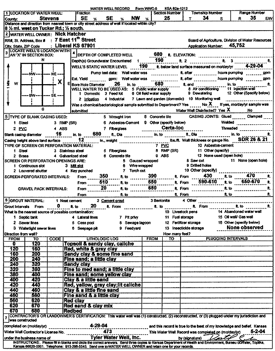
| Owner: Hatcher, Nick | Status: Constructed | ||
| Location: T34S, R35W, Sec. 25, SE SE NW | County: Stevens | ||
| Directions: 8.5 mi W on Tucker Rd, .5 mi S | |||
| Latitude: 37.0620909 | Longitude: -101.0767119 | Datum NAD 27 | |
| Latitude: 37.0621168 | Longitude: -101.0771555 | Datum NAD 83 | |
| Longitude and latitude calculated by Survey from township-range-section-quarter calls. Only good to within the quarter call accuracy. | |||
| View well on interactive map | |||
| General Info | ||
| Well Depth: 680 ft. | Elevation: ft. | |
| Static Water Level: 190 ft. | Est. Yield: gpm. | |
| Comp. Date: 29-Apr-2004 | Well Use: Irrigation | |
| DWR Applic. #: 45752 | Other ID: | |
| Links | |
| No Wizard information available. | |
| View info from WIMAS Water Right Data base... | |
| Driller Info | ||
| Driller: Destal Tyler Water Well Service | License #: 473 | |
| Scanned Form | View scan |
|
Chemical Sample Submitted?:
Water Well disinfected?: | ||
| Casing Info | ||
| Casing Type:
Casing Joints: |
Diam: in. to ft | |
| Casing height above land surface: in
Casing Weight: lbs/ft Wall thickness or gauge no.: | ||
| Screen and Perforation Info | ||
| Screen Type: | Screen Openings: | |
| Screen-perforated intervals | From: ft to ft | |
| Gravel pack intervals | From: ft to ft | |
| Grout Info | ||
| Grout used: | From: to ft | |
| Source of Possible Contamination | ||
| Source: | ||
| Direction from well: | Distance: ft | |
| Lithologic Log
(Log data entered by KGS.) | ||
| From: 0 ft. to 120 ft. | topsoil and sandy clay, caliche | |
| From: 120 ft. to 160 ft. | red, white and gray clay | |
| From: 160 ft. to 200 ft. | sandy clay and some fine sand | |
| From: 200 ft. to 240 ft. | fine sand; a little clay | |
| From: 240 ft. to 320 ft. | sandy clay | |
| From: 320 ft. to 380 ft. | fine to medium sand; a little clay | |
| From: 380 ft. to 400 ft. | fine sand; some yellow clay | |
| From: 400 ft. to 420 ft. | clay and a little sand | |
| From: 420 ft. to 440 ft. | red, yellow, gray clay; lit caliche | |
| From: 440 ft. to 460 ft. | clay and a little fine sand | |
| From: 460 ft. to 580 ft. | fine sand and a little clay | |
| From: 580 ft. to 620 ft. | red clay | |
| From: 620 ft. to 670 ft. | red sand and clay mix | |
| From: 670 ft. to 680 ft. | red bed | |