|
|
|
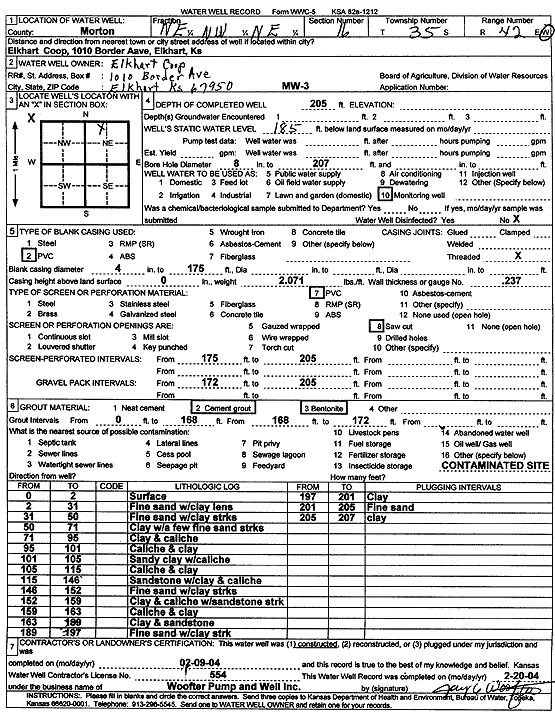
Specific Water Well Detail |
|
|
| Location Info | |||
| Owner: Elkhart Coop | Status: Constructed | ||
| Location: T35S, R42W, Sec. 16, NE NW NE | County: Morton | ||
| Directions: 1010 Border Ave, Elkhart | |||
| Latitude: 37.0096411 | Longitude: -101.8862288 | Datum NAD 27 | |
| Latitude: 37.0096648 | Longitude: -101.886673 | Datum NAD 83 | |
| Longitude and latitude calculated by Survey from township-range-section-quarter calls. Only good to within the quarter call accuracy. | |||
| View well on interactive map | |||
| General Info | ||
| Well Depth: 205 ft. | Elevation: ft. | |
| Static Water Level: 185 ft. | Est. Yield: gpm. | |
| Comp. Date: 09-Feb-2004 | Well Use: Monitoring well/observation/piezometer | |
| DWR Applic. #: | Other ID: MW 3 | |
| Driller Info | ||
| Driller: Jay C. Woofter Pump & Well, Inc. | License #: 554 | |
| Scanned Form | View scan |
|
Chemical Sample Submitted?:
Water Well disinfected?: | ||
| Casing Info | ||
| Casing Type:
Casing Joints: |
Diam: in. to ft | |
| Casing height above land surface: in
Casing Weight: lbs/ft Wall thickness or gauge no.: | ||
| Screen and Perforation Info | ||
| Screen Type: | Screen Openings: | |
| Screen-perforated intervals | From: ft to ft | |
| Gravel pack intervals | From: ft to ft | |
| Grout Info | ||
| Grout used: | From: to ft | |
| Source of Possible Contamination | ||
| Source: | ||
| Direction from well: | Distance: ft | |
| Lithologic Log
(Log data entered by KGS.) | ||
| From: 0 ft. to 2 ft. | surface | |
| From: 2 ft. to 31 ft. | fine sand with clay lens | |
| From: 31 ft. to 50 ft. | fine sand with clay streaks | |
| From: 50 ft. to 71 ft. | clay with a few fine sand streaks | |
| From: 71 ft. to 95 ft. | clay and caliche | |
| From: 95 ft. to 101 ft. | caliche and clay | |
| From: 101 ft. to 105 ft. | sandy clay with caliche | |
| From: 105 ft. to 115 ft. | caliche and clay | |
| From: 115 ft. to 146 ft. | sandstone with clay and caliche | |
| From: 146 ft. to 152 ft. | fine sand with clay streaks | |
| From: 152 ft. to 159 ft. | clay and caliche with sandstone strk | |
| From: 159 ft. to 163 ft. | caliche and clay | |
| From: 163 ft. to 189 ft. | clay and sandstone | |
| From: 189 ft. to 197 ft. | fine sand with clay strk | |
| From: 197 ft. to 201 ft. | clay | |
| From: 201 ft. to 205 ft. | fine sand | |
| From: 205 ft. to 207 ft. | clay | |