|
|
|
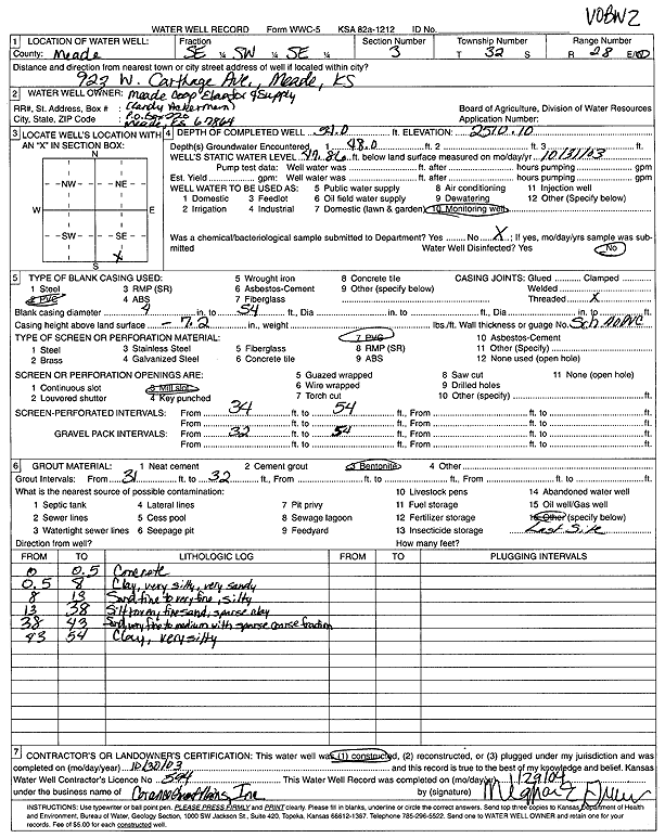
Specific Water Well Detail |
|
|
| Location Info | |||
| Owner: Meade Coop Elevator and Supply | Status: Constructed | ||
| Location: T32S, R28W, Sec. 3, SE SW SE | County: Meade | ||
| Directions: 923 W Carthage Ave, Meade | |||
| Latitude: 37.2863611 | Longitude: -100.3499698 | Datum NAD 27 | |
| Latitude: 37.286385 | Longitude: -100.3503936 | Datum NAD 83 | |
| Longitude and latitude calculated by Survey from township-range-section-quarter calls. Only good to within the quarter call accuracy. | |||
| View well on interactive map | |||
| General Info | ||
| Well Depth: 54 ft. | Elevation: 2510.1 ft. | |
| Static Water Level: 47.86 ft. | Est. Yield: gpm. | |
| Comp. Date: 30-Oct-2003 | Well Use: Monitoring well/observation/piezometer | |
| DWR Applic. #: | Other ID: VOBW 2 | |
| Driller Info | ||
| Driller: Coranco Great Plains, Inc. | License #: 594 | |
| Scanned Form | View scan |
|
Chemical Sample Submitted?:
Water Well disinfected?: | ||
| Casing Info | ||
| Casing Type:
Casing Joints: |
Diam: in. to ft | |
| Casing height above land surface: in
Casing Weight: lbs/ft Wall thickness or gauge no.: | ||
| Screen and Perforation Info | ||
| Screen Type: | Screen Openings: | |
| Screen-perforated intervals | From: ft to ft | |
| Gravel pack intervals | From: ft to ft | |
| Grout Info | ||
| Grout used: | From: to ft | |
| Source of Possible Contamination | ||
| Source: | ||
| Direction from well: | Distance: ft | |
| Lithologic Log
(Log data entered by KGS.) | ||
| From: 0 ft. to .5 ft. | concrete | |
| From: .5 ft. to 8 ft. | clay, very silty, very sandy | |
| From: 8 ft. to 13 ft. | sand fine to very fine, silty | |
| From: 13 ft. to 38 ft. | silty to very fine sand, sparse clay | |
| From: 38 ft. to 43 ft. | sand, very fine to medium with sparse coarse | |
| From: 43 ft. to 54 ft. | clay, very silty | |