|
|
|
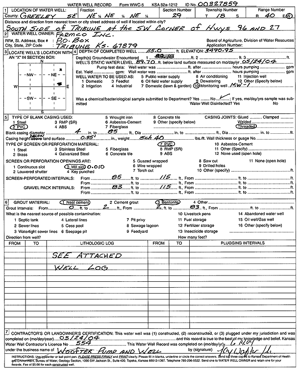
Specific Water Well Detail |
|
|
| Location Info | |||
| Owner: Farmco Inc | Status: Constructed | ||
| Location: T18S, R40W, Sec. 29, SE NE NE NE | County: Greeley | ||
| Directions: SW corner of Hwy 96 and 27, S side Tribune | |||
| Latitude: 38.4645112 | Longitude: -101.7525872 | Datum NAD 27 | |
| Latitude: 38.4645268 | Longitude: -101.7530373 | Datum NAD 83 | |
| Longitude and latitude calculated by Survey from township-range-section-quarter calls. Only good to within the quarter call accuracy. | |||
| View well on interactive map | |||
| General Info | ||
| Well Depth: 115 ft. | Elevation: 3490.95 ft. | |
| Static Water Level: 89.7 ft. | Est. Yield: gpm. | |
| Comp. Date: 24-May-2004 | Well Use: Monitoring well/observation/piezometer | |
| DWR Applic. #: | Other ID: MW 1 | |
| Driller Info | ||
| Driller: Jay C. Woofter Pump & Well, Inc. | License #: 554 | |
| Scanned Form | View scan |
|
Chemical Sample Submitted?:
Water Well disinfected?: | ||
| Casing Info | ||
| Casing Type:
Casing Joints: |
Diam: in. to ft | |
| Casing height above land surface: in
Casing Weight: lbs/ft Wall thickness or gauge no.: | ||
| Screen and Perforation Info | ||
| Screen Type: | Screen Openings: | |
| Screen-perforated intervals | From: ft to ft | |
| Gravel pack intervals | From: ft to ft | |
| Grout Info | ||
| Grout used: | From: to ft | |
| Source of Possible Contamination | ||
| Source: | ||
| Direction from well: | Distance: ft | |