|
|
|
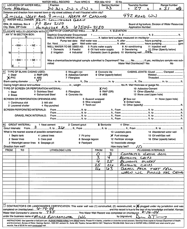
Specific Water Well Detail |
|
|
| Location Info | |||
| Owner: ADM-Collingwood Grain | Status: Plugged | ||
| Location: T27S, R31W, Sec. 23, SW SW SW SW | County: Haskell | ||
| Directions: 492 Rd WW - from Copeland: 3 mi W, 9 mi N | |||
| Latitude: 37.6787764 | Longitude: -100.6879403 | Datum NAD 27 | |
| Latitude: 37.6788004 | Longitude: -100.6883755 | Datum NAD 83 | |
| Longitude and latitude calculated by Survey from township-range-section-quarter calls. Only good to within the quarter call accuracy. | |||
| View well on interactive map | |||
| General Info | ||
| Well Depth: 63 ft. | Elevation: ft. | |
| Static Water Level: ft. | Est. Yield: gpm. | |
| Comp. Date: 14-Jun-2004 | Well Use: Recovery/Soil Vapor Extraction/Soil Vent | |
| DWR Applic. #: | Other ID: | |
| Driller Info | ||
| Driller: Milco Environmental Services | License #: 735 | |
| Scanned Form | View scan |
| Casing Info | ||
|
Casing Type:
Diam: in. Casing height above land surface: in | ||
| Grout Info | ||
| Grout used: | From: to ft | |
| Source of Possible Contamination | ||
| Source: | ||
| Direction from well: | Distance: ft | |