|
|
|
Specific Water Well Detail |
|
|
| Location Info | |||
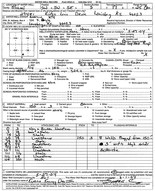
| Owner: Hill, Andrew | Status: Constructed | ||
| Location: T17S, R25E, Sec. 5, SW SW SE | County: Miami | ||
| Directions: 29481 Ridge Line Dr, Louisburg (eight 150-foot bores) | |||
| Latitude: 38.5927444 | Longitude: -94.6652894 | Datum NAD 27 | |
| Latitude: 38.5927569 | Longitude: -94.6655237 | Datum NAD 83 | |
| Longitude and latitude calculated by Survey from township-range-section-quarter calls. Only good to within the quarter call accuracy. | |||
| View well on interactive map | |||
| General Info | ||
| Well Depth: 150 ft. | Elevation: ft. | |
| Static Water Level: ft. | Est. Yield: gpm. | |
| Comp. Date: 27-May-2004 | Well Use: Heat Pump (Closed Loop/Disposal), Geothermal | |
| DWR Applic. #: | Other ID: | |
| Driller Info | ||
| Driller: Evans Energy Development, Inc. | License #: 561 | |
| Scanned Form | View scan |
|
Chemical Sample Submitted?:
Water Well disinfected?: | ||
| Casing Info | ||
| Casing Type:
Casing Joints: |
Diam: in. to ft | |
| Casing height above land surface: in
Casing Weight: lbs/ft Wall thickness or gauge no.: | ||
| Screen and Perforation Info | ||
| Screen Type: | Screen Openings: | |
| Screen-perforated intervals | From: ft to ft | |
| Gravel pack intervals | From: ft to ft | |
| Grout Info | ||
| Grout used: | From: to ft | |
| Source of Possible Contamination | ||
| Source: | ||
| Direction from well: | Distance: ft | |
| Lithologic Log
(Log data entered by KGS.) | ||
| From: 0 ft. to 3 ft. | clay and broken limestone | |
| From: 3 ft. to 18 ft. | limestone and shale | |
| From: 18 ft. to 65 ft. | shale | |
| From: 65 ft. to 78 ft. | limestone | |
| From: 78 ft. to 83 ft. | shale | |
| From: 83 ft. to 94 ft. | sandstone | |
| From: 94 ft. to 107 ft. | shale | |
| From: 107 ft. to 111 ft. | limestone | |
| From: 111 ft. to 116 ft. | shale | |
| From: 116 ft. to 118 ft. | limestone | |
| From: 118 ft. to 150 ft. | shale | |