|
|
|
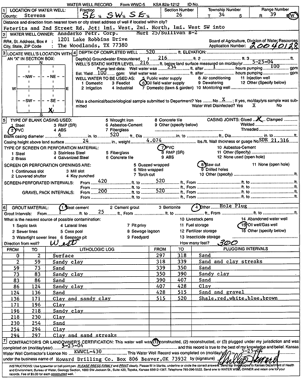
Specific Water Well Detail |
|
|
| Location Info | |||
| Owner: Anadarko Petroleum Corp. | Status: Constructed | ||
| Location: T34S, R39W, Sec. 26, SE SW SE | County: Stevens | ||
| Directions: from Feterita and 2nd St: 1 mi W, 2 mi N, 1 mi W, SW into site | |||
| Latitude: 37.0547669 | Longitude: -101.5246018 | Datum NAD 27 | |
| Latitude: 37.0547936 | Longitude: -101.5250394 | Datum NAD 83 | |
| Longitude and latitude calculated by Survey from township-range-section-quarter calls. Only good to within the quarter call accuracy. | |||
| View well on interactive map | |||
| General Info | ||
| Well Depth: 520 ft. | Elevation: ft. | |
| Static Water Level: 216 ft. | Est. Yield: 100 gpm. | |
| Comp. Date: 25-May-2004 | Well Use: Oil Field Water Supply | |
| DWR Applic. #: 20040128 | Other ID: Murf 25/Sullivan B 2 | |
| Links | |
| No Wizard information available. | |
| View info from WIMAS Water Right Data base... | |
| Driller Info | ||
| Driller: Howard Drilling Company AG, LLC | License #: 430 | |
| Scanned Form | View scan |
|
Chemical Sample Submitted?:
Water Well disinfected?: | ||
| Casing Info | ||
| Casing Type:
Casing Joints: |
Diam: in. to ft | |
| Casing height above land surface: in
Casing Weight: lbs/ft Wall thickness or gauge no.: | ||
| Screen and Perforation Info | ||
| Screen Type: | Screen Openings: | |
| Screen-perforated intervals | From: ft to ft | |
| Gravel pack intervals | From: ft to ft | |
| Grout Info | ||
| Grout used: | From: to ft | |
| Source of Possible Contamination | ||
| Source: | ||
| Direction from well: | Distance: ft | |
| Lithologic Log
(Log data entered by KGS.) | ||
| From: 0 ft. to 2 ft. | surface | |
| From: 2 ft. to 59 ft. | sandy clay | |
| From: 59 ft. to 73 ft. | sand | |
| From: 73 ft. to 83 ft. | sandy clay | |
| From: 83 ft. to 86 ft. | sand | |
| From: 86 ft. to 124 ft. | sandy clay | |
| From: 124 ft. to 136 ft. | sand | |
| From: 136 ft. to 171 ft. | clay and sandy clay | |
| From: 171 ft. to 196 ft. | clay | |
| From: 196 ft. to 218 ft. | sandy clay | |
| From: 218 ft. to 230 ft. | clay | |
| From: 230 ft. to 254 ft. | sand | |
| From: 254 ft. to 294 ft. | clay | |
| From: 294 ft. to 297 ft. | clay and sand streaks | |
| From: 297 ft. to 318 ft. | sand | |
| From: 318 ft. to 339 ft. | sand and clay streaks | |
| From: 339 ft. to 350 ft. | sand | |
| From: 350 ft. to 390 ft. | sandy clay | |
| From: 390 ft. to 407 ft. | sand | |
| From: 407 ft. to 428 ft. | clay | |
| From: 428 ft. to 515 ft. | sand and gravel | |
| From: 515 ft. to 520 ft. | shale, red, white, blue, brown | |