|
|
|
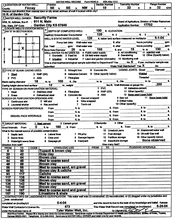
Specific Water Well Detail |
|
|
| Location Info | |||
| Owner: Security Farms | Status: Constructed | ||
| Location: T22S, R32W, Sec. 19, SE SE NW | County: Finney | ||
| Directions: from Garden City: 10 mi N | |||
| Latitude: 38.1281222 | Longitude: -100.8752282 | Datum NAD 27 | |
| Latitude: 38.1281446 | Longitude: -100.8756647 | Datum NAD 83 | |
| Longitude and latitude calculated by Survey from township-range-section-quarter calls. Only good to within the quarter call accuracy. | |||
| View well on interactive map | |||
| General Info | ||
| Well Depth: 190 ft. | Elevation: ft. | |
| Static Water Level: 120 ft. | Est. Yield: gpm. | |
| Comp. Date: 04-Jun-2004 | Well Use: Irrigation | |
| DWR Applic. #: 17792 | Other ID: | |
| Links | |
| No Wizard information available. | |
| View info from WIMAS Water Right Data base... | |
| Driller Info | ||
| Driller: Destal Tyler Water Well Service | License #: 473 | |
| Scanned Form | View scan |
|
Chemical Sample Submitted?:
Water Well disinfected?: | ||
| Casing Info | ||
| Casing Type:
Casing Joints: |
Diam: in. to ft | |
| Casing height above land surface: in
Casing Weight: lbs/ft Wall thickness or gauge no.: | ||
| Screen and Perforation Info | ||
| Screen Type: | Screen Openings: | |
| Screen-perforated intervals | From: ft to ft | |
| Gravel pack intervals | From: ft to ft | |
| Grout Info | ||
| Grout used: | From: to ft | |
| Source of Possible Contamination | ||
| Source: | ||
| Direction from well: | Distance: ft | |
| Lithologic Log
(Log data entered by KGS.) | ||
| From: 0 ft. to 30 ft. | topsoil and brown clay | |
| From: 30 ft. to 42 ft. | gray clay | |
| From: 42 ft. to 44 ft. | brown clay | |
| From: 44 ft. to 48 ft. | med to coarse sand | |
| From: 48 ft. to 58 ft. | brown clay | |
| From: 58 ft. to 66 ft. | med to coarse sand, sm gravel | |
| From: 66 ft. to 93 ft. | brown clay and caliche | |
| From: 93 ft. to 117 ft. | caliche | |
| From: 117 ft. to 135 ft. | med to coarse sand | |
| From: 135 ft. to 136 ft. | brown clay | |
| From: 136 ft. to 142 ft. | med to coarse sand, sm gravel | |
| From: 142 ft. to 148 ft. | brown clay | |
| From: 148 ft. to 157 ft. | med to coarse sand and gravel | |
| From: 157 ft. to 190 ft. | limestone and shale | |