|
|
|
Specific Water Well Detail |
|
|
| Location Info | |||
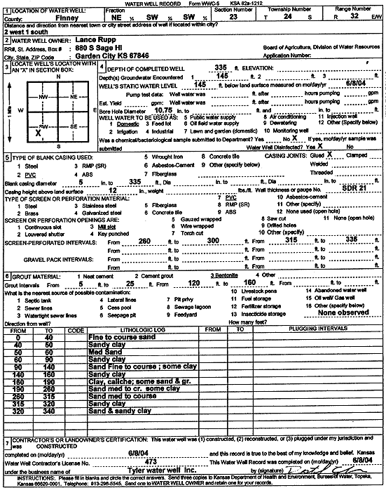
| Owner: Rupp, Lance | Status: Constructed | ||
| Location: T24S, R32W, Sec. 23, NE SW SW | County: Finney | ||
| Directions: From Garden City: 2 mi W, 1 mi S. | |||
| Latitude: 37.948477 | Longitude: -100.8068696 | Datum NAD 27 | |
| Latitude: 37.9484997 | Longitude: -100.8073069 | Datum NAD 83 | |
| Longitude and latitude calculated by Survey from township-range-section-quarter calls. Only good to within the quarter call accuracy. | |||
| View well on interactive map | |||
| General Info | ||
| Well Depth: 335 ft. | Elevation: ft. | |
| Static Water Level: 145 ft. | Est. Yield: gpm. | |
| Comp. Date: 08-Jun-2004 | Well Use: Domestic | |
| DWR Applic. #: | Other ID: | |
| Driller Info | ||
| Driller: Destal Tyler Water Well Service | License #: 473 | |
| Scanned Form | View scan |
|
Chemical Sample Submitted?:
Water Well disinfected?: | ||
| Casing Info | ||
| Casing Type:
Casing Joints: |
Diam: in. to ft | |
| Casing height above land surface: in
Casing Weight: lbs/ft Wall thickness or gauge no.: | ||
| Screen and Perforation Info | ||
| Screen Type: | Screen Openings: | |
| Screen-perforated intervals | From: ft to ft | |
| Gravel pack intervals | From: ft to ft | |
| Grout Info | ||
| Grout used: | From: to ft | |
| Source of Possible Contamination | ||
| Source: | ||
| Direction from well: | Distance: ft | |
| Lithologic Log
(Log data entered by KGS.) | ||
| From: 0 ft. to 40 ft. | fine to coarse sand | |
| From: 40 ft. to 50 ft. | sandy clay | |
| From: 50 ft. to 60 ft. | medium sand | |
| From: 60 ft. to 90 ft. | sandy clay | |
| From: 90 ft. to 140 ft. | fine to coarse sand with some clay | |
| From: 140 ft. to 160 ft. | sandy clay | |
| From: 160 ft. to 190 ft. | clay, caliche; some sand and gravel | |
| From: 190 ft. to 260 ft. | medium to coarse sand with some clay | |
| From: 260 ft. to 315 ft. | medium to coarse sand | |
| From: 315 ft. to 320 ft. | sandy clay | |
| From: 320 ft. to 340 ft. | sand and sandy clay | |