|
|
|
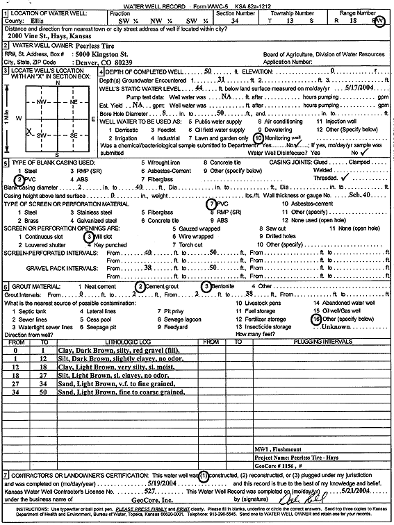
Specific Water Well Detail |
|
|
| Location Info | |||
| Owner: Peerless Tire | Status: Constructed | ||
| Location: T13S, R18W, Sec. 34, SW NW SW | County: Ellis | ||
| Directions: 2000 Vine St, Hays | |||
| Latitude: 38.8754908 | Longitude: -99.3163413 | Datum NAD 27 | |
| Latitude: 38.8755025 | Longitude: -99.3167223 | Datum NAD 83 | |
| Longitude and latitude calculated by Survey from township-range-section-quarter calls. Only good to within the quarter call accuracy. | |||
| View well on interactive map | |||
| General Info | ||
| Well Depth: 50 ft. | Elevation: ft. | |
| Static Water Level: 44 ft. | Est. Yield: gpm. | |
| Comp. Date: 19-May-2004 | Well Use: Monitoring well/observation/piezometer | |
| DWR Applic. #: | Other ID: MW 1 | |
| Driller Info | ||
| Driller: GeoCore Services Inc. | License #: 527 | |
| Scanned Form | View scan |
|
Chemical Sample Submitted?:
Water Well disinfected?: | ||
| Casing Info | ||
| Casing Type:
Casing Joints: |
Diam: in. to ft | |
| Casing height above land surface: in
Casing Weight: lbs/ft Wall thickness or gauge no.: | ||
| Screen and Perforation Info | ||
| Screen Type: | Screen Openings: | |
| Screen-perforated intervals | From: ft to ft | |
| Gravel pack intervals | From: ft to ft | |
| Grout Info | ||
| Grout used: | From: to ft | |
| Source of Possible Contamination | ||
| Source: | ||
| Direction from well: | Distance: ft | |
| Lithologic Log
(Log data entered by KGS.) | ||
| From: 0 ft. to 1 ft. | silty clay, dark brown, with red gravel (fill) | |
| From: 1 ft. to 12 ft. | silt, dark brown, slightly clayey, no odor | |
| From: 12 ft. to 18 ft. | clay, light brown, very silty, slightly moist | |
| From: 18 ft. to 27 ft. | silt, light brown, slightly clayey, no odor | |
| From: 27 ft. to 34 ft. | very fine to fine sand, light brown | |
| From: 34 ft. to 50 ft. | fine to coarse sand, light brown | |