|
|
|
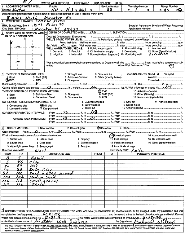
Specific Water Well Detail |
|
|
| Location Info | |||
| Owner: Sumner Farms | Status: Constructed | ||
| Location: T1S, R25W, Sec. 20, NW NW NW | County: Norton | ||
| Directions: from Norcatur: 8 mi N | |||
| Latitude: 39.9569869 | Longitude: -100.1680566 | Datum NAD 27 | |
| Latitude: 39.9569925 | Longitude: -100.1684703 | Datum NAD 83 | |
| Longitude and latitude calculated by Survey from township-range-section-quarter calls. Only good to within the quarter call accuracy. | |||
| View well on interactive map | |||
| General Info | ||
| Well Depth: 116 ft. | Elevation: ft. | |
| Static Water Level: ft. | Est. Yield: 10 gpm. | |
| Comp. Date: 04-Jun-2004 | Well Use: Domestic, Livestock | |
| DWR Applic. #: | Other ID: | |
| Driller Info | ||
| Driller: Wilcox Well Drilling, LLC | License #: 701 | |
| Scanned Form | View scan |
|
Chemical Sample Submitted?:
Water Well disinfected?: | ||
| Casing Info | ||
| Casing Type:
Casing Joints: |
Diam: in. to ft | |
| Casing height above land surface: in
Casing Weight: lbs/ft Wall thickness or gauge no.: | ||
| Screen and Perforation Info | ||
| Screen Type: | Screen Openings: | |
| Screen-perforated intervals | From: ft to ft | |
| Gravel pack intervals | From: ft to ft | |
| Grout Info | ||
| Grout used: | From: to ft | |
| Source of Possible Contamination | ||
| Source: | ||
| Direction from well: | Distance: ft | |
| Lithologic Log
(Log data entered by KGS.) | ||
| From: 0 ft. to 5 ft. | topsoil | |
| From: 5 ft. to 46 ft. | clay | |
| From: 46 ft. to 57 ft. | mag | |
| From: 57 ft. to 85 ft. | brown clay | |
| From: 85 ft. to 100 ft. | sand and clay mixed | |
| From: 100 ft. to 106 ft. | medium sand | |
| From: 106 ft. to 113 ft. | small gravel | |
| From: 113 ft. to 116 ft. | shale | |