|
|
|
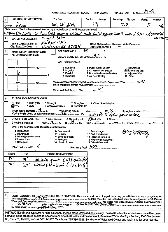
Specific Water Well Detail |
|
|
| Location Info | |||
| Owner: Cargill Salt | Status: Plugged | ||
| Location: T23S, R5W, Sec. 19, SW SE NW | County: Reno | ||
| Directions: In farmfield, next to railroad tracks: 2000' S of G Ave, 1000' W of Severance | |||
| Latitude: 38.0366145 | Longitude: -97.9158873 | Datum NAD 27 | |
| Latitude: 38.0366259 | Longitude: -97.916217 | Datum NAD 83 | |
| Longitude and latitude calculated by Survey from township-range-section-quarter calls. Only good to within the quarter call accuracy. | |||
| View well on interactive map | |||
| General Info | ||
| Well Depth: 60 ft. | Elevation: ft. | |
| Static Water Level: 14.4 ft. | Est. Yield: gpm. | |
| Comp. Date: 09-Jun-2004 | Well Use: Monitoring well/observation/piezometer | |
| DWR Applic. #: | Other ID: M 8 | |
| Driller Info | ||
| Driller: Below Ground Surface, Inc. | License #: 710 | |
| Scanned Form | View scan |
| Casing Info | ||
|
Casing Type:
Diam: in. Casing height above land surface: in | ||
| Grout Info | ||
| Grout used: | From: to ft | |
| Source of Possible Contamination | ||
| Source: | ||
| Direction from well: | Distance: ft | |