|
|
|
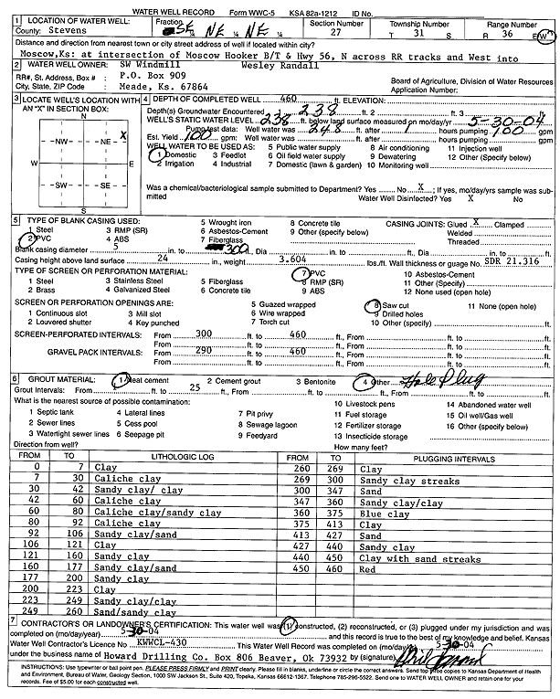
Specific Water Well Detail |
|
|
| Location Info | |||
| Owner: SW Windmill | Status: Constructed | ||
| Location: T31S, R36W, Sec. 27, SE NE NE | County: Stevens | ||
| Directions: from Moscow-Hooker Rd. and Hwy 56, N across RR tracks and W to site | |||
| Latitude: 37.3267955 | Longitude: -101.2132719 | Datum NAD 27 | |
| Latitude: 37.3268193 | Longitude: -101.2137105 | Datum NAD 83 | |
| Longitude and latitude calculated by Survey from township-range-section-quarter calls. Only good to within the quarter call accuracy. | |||
| View well on interactive map | |||
| General Info | ||
| Well Depth: 460 ft. | Elevation: ft. | |
| Static Water Level: 238 ft. | Est. Yield: 100 gpm. | |
| Comp. Date: 30-May-2004 | Well Use: Domestic | |
| DWR Applic. #: | Other ID: | |
| Driller Info | ||
| Driller: Howard Drilling Company AG, LLC | License #: 430 | |
| Scanned Form | View scan |
|
Chemical Sample Submitted?:
Water Well disinfected?: | ||
| Casing Info | ||
| Casing Type:
Casing Joints: |
Diam: in. to ft | |
| Casing height above land surface: in
Casing Weight: lbs/ft Wall thickness or gauge no.: | ||
| Screen and Perforation Info | ||
| Screen Type: | Screen Openings: | |
| Screen-perforated intervals | From: ft to ft | |
| Gravel pack intervals | From: ft to ft | |
| Grout Info | ||
| Grout used: | From: to ft | |
| Source of Possible Contamination | ||
| Source: | ||
| Direction from well: | Distance: ft | |
| Lithologic Log
(Log data entered by KGS.) | ||
| From: 0 ft. to 7 ft. | clay | |
| From: 7 ft. to 30 ft. | caliche clay | |
| From: 30 ft. to 42 ft. | sandy clay / clay | |
| From: 42 ft. to 60 ft. | caliche clay | |
| From: 60 ft. to 80 ft. | caliche clay / sandy clay | |
| From: 80 ft. to 92 ft. | caliche clay | |
| From: 92 ft. to 106 ft. | sandy clay/sand | |
| From: 106 ft. to 121 ft. | clay | |
| From: 121 ft. to 160 ft. | sandy clay | |
| From: 160 ft. to 177 ft. | sandy clay/sand | |
| From: 177 ft. to 200 ft. | sandy clay | |
| From: 200 ft. to 223 ft. | clay | |
| From: 223 ft. to 249 ft. | sandy clay/clay | |
| From: 249 ft. to 260 ft. | sand/sandy clay | |
| From: 260 ft. to 269 ft. | clay | |
| From: 269 ft. to 300 ft. | sandy clay streaks | |
| From: 300 ft. to 347 ft. | sand | |
| From: 347 ft. to 360 ft. | sandy clay/clay | |
| From: 360 ft. to 375 ft. | blue clay | |
| From: 375 ft. to 413 ft. | clay | |
| From: 413 ft. to 427 ft. | sand | |
| From: 427 ft. to 440 ft. | sandy clay | |
| From: 440 ft. to 450 ft. | clay with sand streaks | |
| From: 450 ft. to 460 ft. | red | |