|
|
|
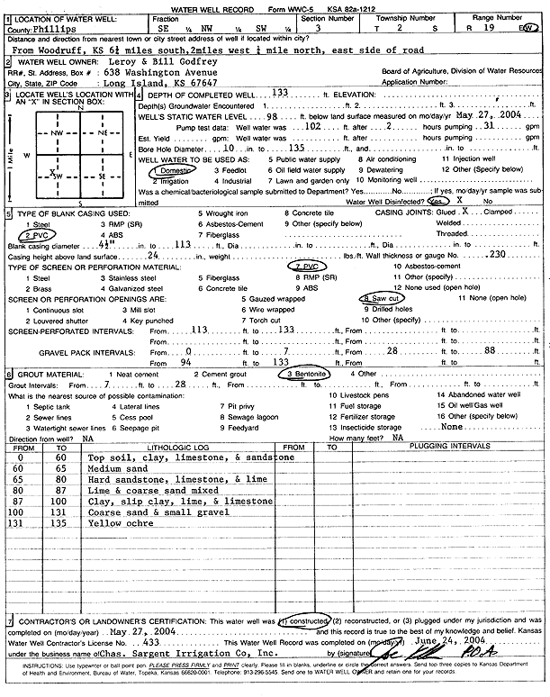
Specific Water Well Detail |
|
|
| Location Info | |||
| Owner: Godfrey, Leroy and Bill | Status: Constructed | ||
| Location: T2S, R19W, Sec. 3, SE NW SW | County: Phillips | ||
| Directions: from Woodruff: 6.25 mi S, 2 mi W, .25 mi N, E side of rd | |||
| Latitude: 39.9051695 | Longitude: -99.4555585 | Datum NAD 27 | |
| Latitude: 39.9051792 | Longitude: -99.4559383 | Datum NAD 83 | |
| Longitude and latitude calculated by Survey from township-range-section-quarter calls. Only good to within the quarter call accuracy. | |||
| View well on interactive map | |||
| General Info | ||
| Well Depth: 133 ft. | Elevation: ft. | |
| Static Water Level: 98 ft. | Est. Yield: gpm. | |
| Comp. Date: 27-May-2004 | Well Use: Domestic | |
| DWR Applic. #: | Other ID: | |
| Driller Info | ||
| Driller: Chas. Sargent Irrigation Co., Inc. | License #: 433 | |
| Scanned Form | View scan |
|
Chemical Sample Submitted?:
Water Well disinfected?: | ||
| Casing Info | ||
| Casing Type:
Casing Joints: |
Diam: in. to ft | |
| Casing height above land surface: in
Casing Weight: lbs/ft Wall thickness or gauge no.: | ||
| Screen and Perforation Info | ||
| Screen Type: | Screen Openings: | |
| Screen-perforated intervals | From: ft to ft | |
| Gravel pack intervals | From: ft to ft | |
| Grout Info | ||
| Grout used: | From: to ft | |
| Source of Possible Contamination | ||
| Source: | ||
| Direction from well: | Distance: ft | |
| Lithologic Log
(Log data entered by KGS.) | ||
| From: 0 ft. to 60 ft. | topsoil, clay, limestone, and sandstone | |
| From: 60 ft. to 65 ft. | medium sand | |
| From: 65 ft. to 80 ft. | hard sandstone, limestone, and lime | |
| From: 80 ft. to 87 ft. | lime and coarse sand mixed | |
| From: 87 ft. to 100 ft. | clay, slip clay, lime, and limestone | |
| From: 100 ft. to 131 ft. | coarse sand and small gravel | |
| From: 131 ft. to 135 ft. | yellow ochre | |