|
|
|
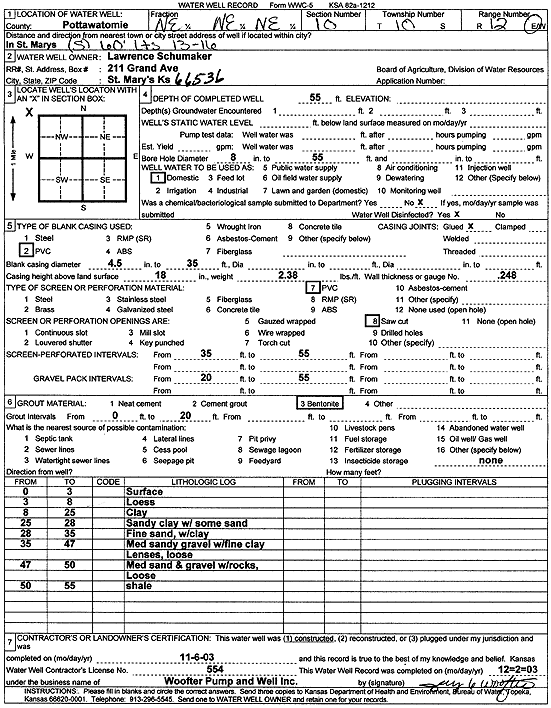
Specific Water Well Detail |
|
|
| Location Info | |||
| Owner: Schumaker, Lawrence | Status: Constructed | ||
| Location: T10S, R12E, Sec. 10, NE NE NE | County: Pottawatomie | ||
| Directions: St Marys | |||
| Latitude: 39.2012367 | Longitude: -96.0553041 | Datum NAD 27 | |
| Latitude: 39.2012339 | Longitude: -96.0555747 | Datum NAD 83 | |
| Longitude and latitude calculated by Survey from township-range-section-quarter calls. Only good to within the quarter call accuracy. | |||
| View well on interactive map | |||
| General Info | ||
| Well Depth: 55 ft. | Elevation: ft. | |
| Static Water Level: ft. | Est. Yield: gpm. | |
| Comp. Date: 06-Nov-2003 | Well Use: Domestic | |
| DWR Applic. #: | Other ID: | |
| Driller Info | ||
| Driller: Jay C. Woofter Pump & Well, Inc. | License #: 554 | |
| Scanned Form | View scan |
|
Chemical Sample Submitted?:
Water Well disinfected?: | ||
| Casing Info | ||
| Casing Type:
Casing Joints: |
Diam: in. to ft | |
| Casing height above land surface: in
Casing Weight: lbs/ft Wall thickness or gauge no.: | ||
| Screen and Perforation Info | ||
| Screen Type: | Screen Openings: | |
| Screen-perforated intervals | From: ft to ft | |
| Gravel pack intervals | From: ft to ft | |
| Grout Info | ||
| Grout used: | From: to ft | |
| Source of Possible Contamination | ||
| Source: | ||
| Direction from well: | Distance: ft | |
| Lithologic Log
(Log data entered by KGS.) | ||
| From: 0 ft. to 3 ft. | surface | |
| From: 3 ft. to 8 ft. | loess | |
| From: 8 ft. to 25 ft. | clay | |
| From: 25 ft. to 28 ft. | sandy clay with some sand | |
| From: 28 ft. to 35 ft. | fine sand with clay | |
| From: 35 ft. to 47 ft. | medium sandy gravel with fine clay lenses, loose | |
| From: 47 ft. to 50 ft. | medium sand and gravel with rocks, loose | |
| From: 50 ft. to 55 ft. | shale | |