|
|
|
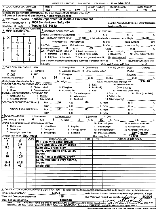
Specific Water Well Detail |
|
|
| Location Info | |||
| Owner: Kansas Dept. of Health and Environment | Status: Constructed | ||
| Location: T23S, R5W, Sec. 17, SW SW SW | County: Reno | ||
| Directions: NE corner of E Avenue G and Hwy 61, Hutchinson | |||
| Latitude: 38.0439399 | Longitude: -97.9022717 | Datum NAD 27 | |
| Latitude: 38.0439513 | Longitude: -97.902601 | Datum NAD 83 | |
| Longitude and latitude calculated by Survey from township-range-section-quarter calls. Only good to within the quarter call accuracy. | |||
| View well on interactive map | |||
| General Info | ||
| Well Depth: 64 ft. | Elevation: ft. | |
| Static Water Level: 11.9 ft. | Est. Yield: gpm. | |
| Comp. Date: 03-Jun-2004 | Well Use: Monitoring well/observation/piezometer | |
| DWR Applic. #: | Other ID: MW 17D | |
| Driller Info | ||
| Driller: Terracon, Inc. | License #: 416 | |
| Scanned Form | View scan |
|
Chemical Sample Submitted?:
Water Well disinfected?: | ||
| Casing Info | ||
| Casing Type:
Casing Joints: |
Diam: in. to ft | |
| Casing height above land surface: in
Casing Weight: lbs/ft Wall thickness or gauge no.: | ||
| Screen and Perforation Info | ||
| Screen Type: | Screen Openings: | |
| Screen-perforated intervals | From: ft to ft | |
| Gravel pack intervals | From: ft to ft | |
| Grout Info | ||
| Grout used: | From: to ft | |
| Source of Possible Contamination | ||
| Source: | ||
| Direction from well: | Distance: ft | |
| Lithologic Log
(Log data entered by KGS.) | ||
| From: 0 ft. to 5 ft. | fill, clay with sand, brown | |
| From: 5 ft. to 5.5 ft. | sand with clay, yellow brown | |
| From: 5.5 ft. to 6 ft. | lean clay, green gray | |
| From: 6 ft. to 10 ft. | very fine to fine sand, yellow brown | |
| From: 10 ft. to 10.5 ft. | fine to medium sand, brown | |
| From: 10.5 ft. to 64.5 ft. | medium to very coarse sand, brown | |
| From: 64.5 ft. to 65 ft. | shale, red | |