|
|
|
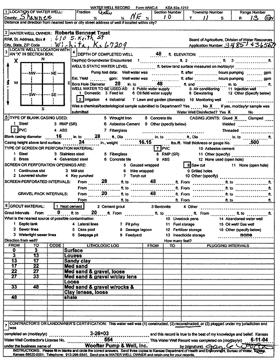
Specific Water Well Detail |
|
|
| Location Info | |||
| Owner: Roberta Bennet Trust | Status: Reconstructed | ||
| Location: T11S, R13E, Sec. 10, NE | County: Shawnee | ||
| Directions: | |||
| Latitude: 39.1126938 | Longitude: -95.9513606 | Datum NAD 27 | |
| Latitude: 39.1126929 | Longitude: -95.9516279 | Datum NAD 83 | |
| Longitude and latitude calculated by Survey from township-range-section-quarter calls. Only good to within the quarter call accuracy. | |||
| View well on interactive map | |||
| General Info | ||
| Well Depth: 48 ft. | Elevation: ft. | |
| Static Water Level: ft. | Est. Yield: gpm. | |
| Comp. Date: 26-Mar-2003 | Well Use: Irrigation | |
| DWR Applic. #: 34851,36550 | Other ID: | |
| Links | |
| No Wizard information available. | |
| View info from WIMAS Water Right Data base... | |
| Driller Info | ||
| Driller: Jay C. Woofter Pump & Well, Inc. | License #: 554 | |
| Scanned Form | View scan |
|
Chemical Sample Submitted?:
Water Well disinfected?: | ||
| Casing Info | ||
| Casing Type:
Casing Joints: |
Diam: in. to ft | |
| Casing height above land surface: in
Casing Weight: lbs/ft Wall thickness or gauge no.: | ||
| Screen and Perforation Info | ||
| Screen Type: | Screen Openings: | |
| Screen-perforated intervals | From: ft to ft | |
| Gravel pack intervals | From: ft to ft | |
| Grout Info | ||
| Grout used: | From: to ft | |
| Source of Possible Contamination | ||
| Source: | ||
| Direction from well: | Distance: ft | |
| Lithologic Log
(Log data entered by KGS.) | ||
| From: 0 ft. to 3 ft. | Surface | |
| From: 3 ft. to 13 ft. | Loess | |
| From: 13 ft. to 17 ft. | Sandy clay | |
| From: 17 ft. to 22 ft. | Medium sand | |
| From: 22 ft. to 27 ft. | Medium sand and gravel, loose | |
| From: 27 ft. to 33 ft. | Medium sand and gravel w/clay lens, loose | |
| From: 33 ft. to 48 ft. | Medium sand and gravel w/rocks and clay lenses, loose | |
| From: 48 ft. to ft. | Shale | |