|
|
|
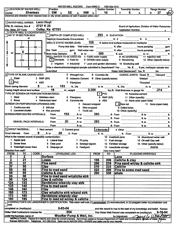
Specific Water Well Detail |
|
|
| Location Info | |||
| Owner: Hoyt, Leon | Status: Constructed | ||
| Location: T6S, R37W, Sec. 18, SW SE NW | County: Sherman | ||
| Directions: | |||
| Latitude: 39.5336841 | Longitude: -101.4953255 | Datum NAD 27 | |
| Latitude: 39.5336824 | Longitude: -101.4957692 | Datum NAD 83 | |
| Longitude and latitude calculated by Survey from township-range-section-quarter calls. Only good to within the quarter call accuracy. | |||
| View well on interactive map | |||
| General Info | ||
| Well Depth: 293 ft. | Elevation: ft. | |
| Static Water Level: 155 ft. | Est. Yield: gpm. | |
| Comp. Date: 03-Jun-2004 | Well Use: Domestic | |
| DWR Applic. #: | Other ID: | |
| Driller Info | ||
| Driller: Jay C. Woofter Pump & Well, Inc. | License #: 554 | |
| Scanned Form | View scan |
|
Chemical Sample Submitted?:
Water Well disinfected?: | ||
| Casing Info | ||
| Casing Type:
Casing Joints: |
Diam: in. to ft | |
| Casing height above land surface: in
Casing Weight: lbs/ft Wall thickness or gauge no.: | ||
| Screen and Perforation Info | ||
| Screen Type: | Screen Openings: | |
| Screen-perforated intervals | From: ft to ft | |
| Gravel pack intervals | From: ft to ft | |
| Grout Info | ||
| Grout used: | From: to ft | |
| Source of Possible Contamination | ||
| Source: | ||
| Direction from well: | Distance: ft | |
| Lithologic Log
(Log data entered by KGS.) | ||
| From: 0 ft. to 2 ft. | Surface | |
| From: 2 ft. to 21 ft. | Loess | |
| From: 21 ft. to 37 ft. | Fine sand | |
| From: 37 ft. to 55 ft. | Clay | |
| From: 55 ft. to 68 ft. | Fine to medium sand | |
| From: 68 ft. to 95 ft. | Caliche and clay | |
| From: 95 ft. to 98 ft. | Fine to medium sand with caliche streak | |
| From: 98 ft. to 124 ft. | Clay and caliche | |
| From: 124 ft. to 133 ft. | Sandstone with sandy clay streak | |
| From: 133 ft. to 145 ft. | Fine to medium sand | |
| From: 145 ft. to 160 ft. | Clay | |
| From: 160 ft. to 173 ft. | Clay with caliche streak with sand streak | |
| From: 173 ft. to 180 ft. | Sandstone with sandy clay | |
| From: 180 ft. to 195 ft. | Fine to medium sand with clay and caliche lens | |
| From: 195 ft. to 206 ft. | Caliche and clay | |
| From: 206 ft. to 219 ft. | Fine sand with clay and caliche streak | |
| From: 219 ft. to 223 ft. | Caliche | |
| From: 223 ft. to 290 ft. | Fine to some medium sand | |
| From: 290 ft. to 300 ft. | Shale | |