|
|
|
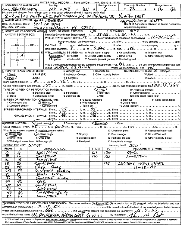
Specific Water Well Detail |
|
|
| Location Info | |||
| Owner: Atherton, Anita | Status: Constructed | ||
| Location: T32S, R16E, Sec. 6, NE NE SW | County: Montgomery | ||
| Directions: from Independence: 2.5 mi N on Hwy 75, .5 mi E | |||
| Latitude: 37.2896297 | Longitude: -95.7026844 | Datum NAD 27 | |
| Latitude: 37.2896957 | Longitude: -95.7029423 | Datum NAD 83 | |
| Longitude and latitude calculated by Survey from township-range-section-quarter calls. Only good to within the quarter call accuracy. | |||
| View well on interactive map | |||
| General Info | ||
| Well Depth: 135 ft. | Elevation: 845 ft. | |
| Static Water Level: 13 ft. | Est. Yield: 3 gpm. | |
| Comp. Date: 10-Feb-2004 | Well Use: Domestic | |
| DWR Applic. #: 304392 | Other ID: | |
| Driller Info | ||
| Driller: Hydro Master Water Well Service | License #: 664 | |
| Scanned Form | View scan |
|
Chemical Sample Submitted?:
Water Well disinfected?: | ||
| Casing Info | ||
| Casing Type:
Casing Joints: |
Diam: in. to ft | |
| Casing height above land surface: in
Casing Weight: lbs/ft Wall thickness or gauge no.: | ||
| Screen and Perforation Info | ||
| Screen Type: | Screen Openings: | |
| Screen-perforated intervals | From: ft to ft | |
| Gravel pack intervals | From: ft to ft | |
| Grout Info | ||
| Grout used: | From: to ft | |
| Source of Possible Contamination | ||
| Source: | ||
| Direction from well: | Distance: ft | |
| Lithologic Log
(Log data entered by KGS.) | ||
| From: 0 ft. to 8 ft. | soil and clay | |
| From: 8 ft. to 16 ft. | sandstone | |
| From: 16 ft. to 18 ft. | limestone | |
| From: 18 ft. to 25 ft. | sandstone | |
| From: 25 ft. to 28 ft. | shale, gray | |
| From: 28 ft. to 33 ft. | shaley sandstone | |
| From: 33 ft. to 35 ft. | shale, gray | |
| From: 35 ft. to 39 ft. | sandstone, limey | |
| From: 39 ft. to 42 ft. | shale | |
| From: 42 ft. to 44 ft. | sandy shale | |
| From: 44 ft. to 45 ft. | limestone | |
| From: 45 ft. to 50 ft. | sandy limestone | |
| From: 50 ft. to 63 ft. | limestone | |
| From: 63 ft. to 120 ft. | shale | |
| From: 120 ft. to 135 ft. | limestone | |