|
|
|
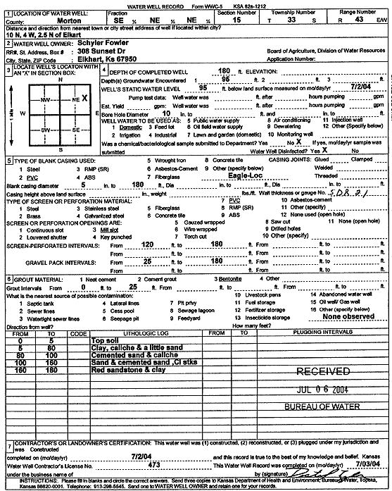
Specific Water Well Detail |
|
|
| Location Info | |||
| Owner: Fowler, Schyler | Status: Constructed | ||
| Location: T33S, R43W, Sec. 15, SE NE NE | County: Morton | ||
| Directions: from Elkhart: 10 mi N, 4 mi W, 2.5 mi N | |||
| Latitude: 37.1824283 | Longitude: -101.9728013 | Datum NAD 27 | |
| Latitude: 37.1824504 | Longitude: -101.9732498 | Datum NAD 83 | |
| Longitude and latitude calculated by Survey from township-range-section-quarter calls. Only good to within the quarter call accuracy. | |||
| View well on interactive map | |||
| General Info | ||
| Well Depth: 180 ft. | Elevation: ft. | |
| Static Water Level: 95 ft. | Est. Yield: gpm. | |
| Comp. Date: 02-Jul-2004 | Well Use: Domestic | |
| DWR Applic. #: | Other ID: | |
| Driller Info | ||
| Driller: Destal Tyler Water Well Service | License #: 473 | |
| Scanned Form | View scan |
|
Chemical Sample Submitted?:
Water Well disinfected?: | ||
| Casing Info | ||
| Casing Type:
Casing Joints: |
Diam: in. to ft | |
| Casing height above land surface: in
Casing Weight: lbs/ft Wall thickness or gauge no.: | ||
| Screen and Perforation Info | ||
| Screen Type: | Screen Openings: | |
| Screen-perforated intervals | From: ft to ft | |
| Gravel pack intervals | From: ft to ft | |
| Grout Info | ||
| Grout used: | From: to ft | |
| Source of Possible Contamination | ||
| Source: | ||
| Direction from well: | Distance: ft | |
| Lithologic Log
(Log data entered by KGS.) | ||
| From: 0 ft. to 5 ft. | top soil | |
| From: 5 ft. to 80 ft. | clay, caliche and a little sand | |
| From: 80 ft. to 100 ft. | cemented sand and caliche | |
| From: 100 ft. to 160 ft. | sand and cemented sand, clay streaks | |
| From: 160 ft. to 180 ft. | red sandstone and clay | |