|
|
|
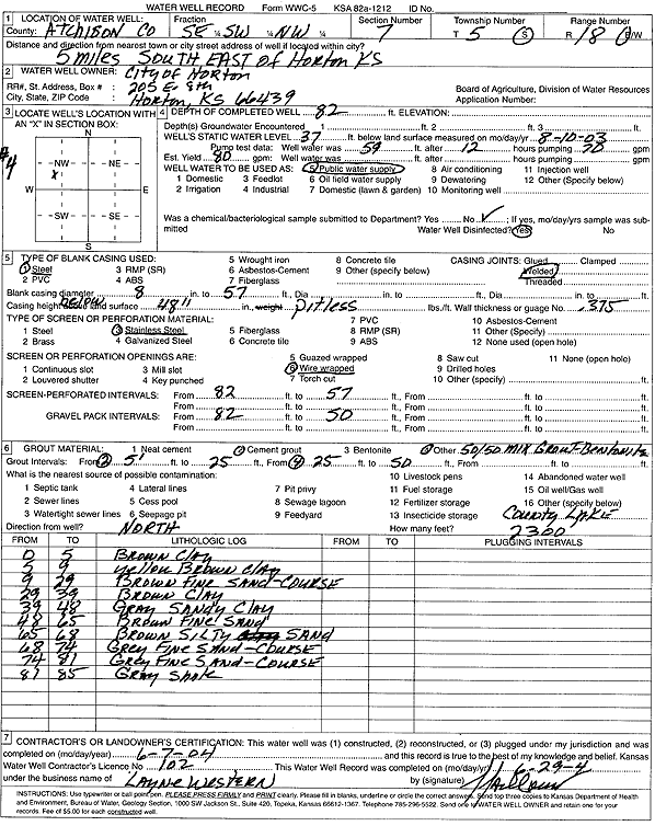
Specific Water Well Detail |
|
|
| Location Info | |||
| Owner: City of Horton | Status: Constructed | ||
| Location: T5S, R18E, Sec. 7, SE SW NW | County: Atchison | ||
| Directions: from Horton: 5 mi SE | |||
| Latitude: 39.631939 | Longitude: -95.4484627 | Datum NAD 27 | |
| Latitude: 39.6319399 | Longitude: -95.4487184 | Datum NAD 83 | |
| Longitude and latitude calculated by Survey from township-range-section-quarter calls. Only good to within the quarter call accuracy. | |||
| View well on interactive map | |||
| General Info | ||
| Well Depth: 82 ft. | Elevation: ft. | |
| Static Water Level: 37 ft. | Est. Yield: 80 gpm. | |
| Comp. Date: 07-Jun-2004 | Well Use: Public Water Supply | |
| DWR Applic. #: | Other ID: | |
| Links | |
| No Wizard information available. | |
| View info from WIMAS Water Right Data base... | |
| Driller Info | ||
| Driller: Layne-Western Co. | License #: 102 | |
| Scanned Form | View scan |
|
Chemical Sample Submitted?:
Water Well disinfected?: | ||
| Casing Info | ||
| Casing Type:
Casing Joints: |
Diam: in. to ft | |
| Casing height above land surface: in
Casing Weight: lbs/ft Wall thickness or gauge no.: | ||
| Screen and Perforation Info | ||
| Screen Type: | Screen Openings: | |
| Screen-perforated intervals | From: ft to ft | |
| Gravel pack intervals | From: ft to ft | |
| Grout Info | ||
| Grout used: | From: to ft | |
| Source of Possible Contamination | ||
| Source: | ||
| Direction from well: | Distance: ft | |
| Lithologic Log
(Log data entered by KGS.) | ||
| From: 0 ft. to 5 ft. | Clay, brown | |
| From: 5 ft. to 9 ft. | Clay, yellow brown | |
| From: 9 ft. to 29 ft. | Fine-coarse sand, brown | |
| From: 29 ft. to 39 ft. | Clay, brown | |
| From: 39 ft. to 48 ft. | Sandy clay, gray | |
| From: 48 ft. to 65 ft. | Fine sand, brown | |
| From: 65 ft. to 68 ft. | Silty sand, brown | |
| From: 68 ft. to 74 ft. | Fine-coarse sand, gray | |
| From: 74 ft. to 81 ft. | Fine-coarse sand, gray | |
| From: 81 ft. to 85 ft. | Shale, gray | |