|
|
|
Specific Water Well Detail |
|
|
| Location Info | |||
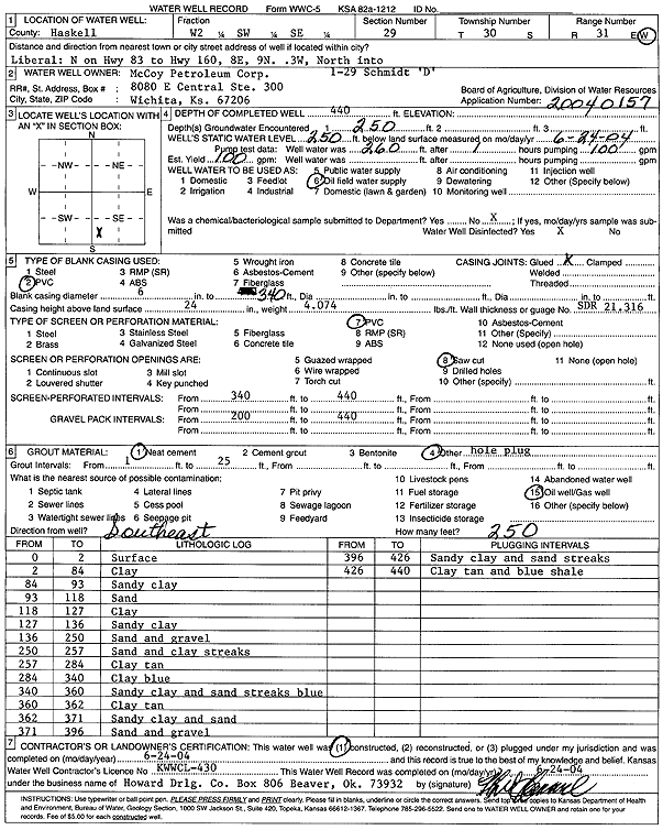
| Owner: McCoy Petroleum Corp. | Status: Constructed | ||
| Location: T30S, R31W, Sec. 29, W2 SW SE | County: Haskell | ||
| Directions: from Liberal: N on Hwy 83 to Hwy 160, 8 mi E, 9 mi N, .3 mi W, N into site | |||
| Latitude: 37.4038645 | Longitude: -100.7328261 | Datum NAD 27 | |
| Latitude: 37.4038872 | Longitude: -100.7332617 | Datum NAD 83 | |
| Longitude and latitude calculated by Survey from township-range-section-quarter calls. Only good to within the quarter call accuracy. | |||
| View well on interactive map | |||
| General Info | ||
| Well Depth: 440 ft. | Elevation: ft. | |
| Static Water Level: 250 ft. | Est. Yield: 100 gpm. | |
| Comp. Date: 24-Jun-2004 | Well Use: Oil Field Water Supply | |
| DWR Applic. #: 20040157 | Other ID: Schmidt D 1-29 | |
| Links | |
| No Wizard information available. | |
| View info from WIMAS Water Right Data base... | |
| Driller Info | ||
| Driller: Howard Drilling Company AG, LLC | License #: 430 | |
| Scanned Form | View scan |
|
Chemical Sample Submitted?:
Water Well disinfected?: | ||
| Casing Info | ||
| Casing Type:
Casing Joints: |
Diam: in. to ft | |
| Casing height above land surface: in
Casing Weight: lbs/ft Wall thickness or gauge no.: | ||
| Screen and Perforation Info | ||
| Screen Type: | Screen Openings: | |
| Screen-perforated intervals | From: ft to ft | |
| Gravel pack intervals | From: ft to ft | |
| Grout Info | ||
| Grout used: | From: to ft | |
| Source of Possible Contamination | ||
| Source: | ||
| Direction from well: | Distance: ft | |
| Lithologic Log
(Log data entered by KGS.) | ||
| From: 0 ft. to 2 ft. | surface | |
| From: 2 ft. to 84 ft. | clay | |
| From: 84 ft. to 93 ft. | sandy clay | |
| From: 93 ft. to 118 ft. | sand | |
| From: 118 ft. to 127 ft. | clay | |
| From: 127 ft. to 136 ft. | sandy clay | |
| From: 136 ft. to 250 ft. | sand and gravel | |
| From: 250 ft. to 257 ft. | sand and clay streaks | |
| From: 257 ft. to 284 ft. | clay tan | |
| From: 284 ft. to 340 ft. | clay blue | |
| From: 340 ft. to 360 ft. | sandy clay and sand streaks blue | |
| From: 360 ft. to 362 ft. | clay tan | |
| From: 362 ft. to 371 ft. | sandy clay and sand | |
| From: 371 ft. to 396 ft. | sand and gravel | |
| From: 396 ft. to 426 ft. | sandy clay and sand streaks | |
| From: 426 ft. to 440 ft. | clay tan and blue shale | |