|
|
|
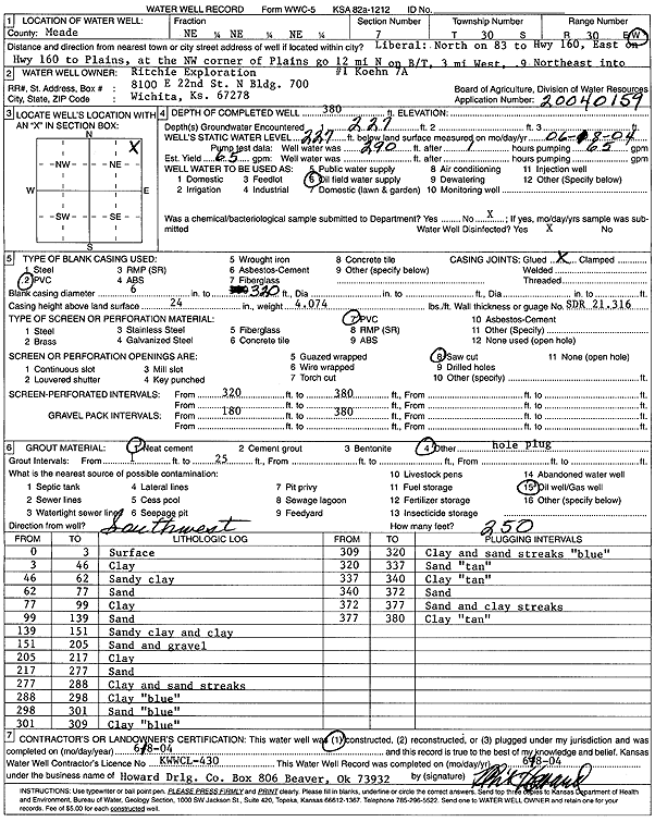
Specific Water Well Detail |
|
|
| Location Info | |||
| Owner: Ritchie Exploration | Status: Constructed | ||
| Location: T30S, R30W, Sec. 7, NE NE NE | County: Meade | ||
| Directions: from Liberal: N on Hwy 83 to Hwy 160, E to Plains, 12 mi N of the NW corner of Plains on b/t, 3 mi W, 0.9 mi NE | |||
| Latitude: 37.4593289 | Longitude: -100.6349541 | Datum NAD 27 | |
| Latitude: 37.4593526 | Longitude: -100.6353874 | Datum NAD 83 | |
| Longitude and latitude calculated by Survey from township-range-section-quarter calls. Only good to within the quarter call accuracy. | |||
| View well on interactive map | |||
| General Info | ||
| Well Depth: 380 ft. | Elevation: ft. | |
| Static Water Level: 227 ft. | Est. Yield: 65 gpm. | |
| Comp. Date: 18-Jun-2004 | Well Use: Oil Field Water Supply | |
| DWR Applic. #: 20040159 | Other ID: Koehn 'A' 1-7 | |
| Links | |
| No Wizard information available. | |
| View info from WIMAS Water Right Data base... | |
| Driller Info | ||
| Driller: Howard Drilling Company AG, LLC | License #: 430 | |
| Scanned Form | View scan |
|
Chemical Sample Submitted?:
Water Well disinfected?: | ||
| Casing Info | ||
| Casing Type:
Casing Joints: |
Diam: in. to ft | |
| Casing height above land surface: in
Casing Weight: lbs/ft Wall thickness or gauge no.: | ||
| Screen and Perforation Info | ||
| Screen Type: | Screen Openings: | |
| Screen-perforated intervals | From: ft to ft | |
| Gravel pack intervals | From: ft to ft | |
| Grout Info | ||
| Grout used: | From: to ft | |
| Source of Possible Contamination | ||
| Source: | ||
| Direction from well: | Distance: ft | |
| Lithologic Log
(Log data entered by KGS.) | ||
| From: 0 ft. to 3 ft. | surface | |
| From: 3 ft. to 46 ft. | clay | |
| From: 46 ft. to 62 ft. | sandy clay | |
| From: 62 ft. to 77 ft. | sand | |
| From: 77 ft. to 99 ft. | clay | |
| From: 99 ft. to 139 ft. | sand | |
| From: 139 ft. to 151 ft. | sandy clay and clay | |
| From: 151 ft. to 205 ft. | sand and gravel | |
| From: 205 ft. to 217 ft. | clay | |
| From: 217 ft. to 277 ft. | sand | |
| From: 277 ft. to 288 ft. | clay and sand streaks | |
| From: 288 ft. to 298 ft. | clay, blue | |
| From: 298 ft. to 301 ft. | sand, blue | |
| From: 301 ft. to 309 ft. | clay, blue | |
| From: 309 ft. to 320 ft. | clay and sand streaks, blue | |
| From: 320 ft. to 337 ft. | sand, tan | |
| From: 337 ft. to 340 ft. | clay, tan | |
| From: 340 ft. to 372 ft. | sand | |
| From: 372 ft. to 377 ft. | sand and clay streaks | |
| From: 377 ft. to 380 ft. | clay, tan | |