|
|
|
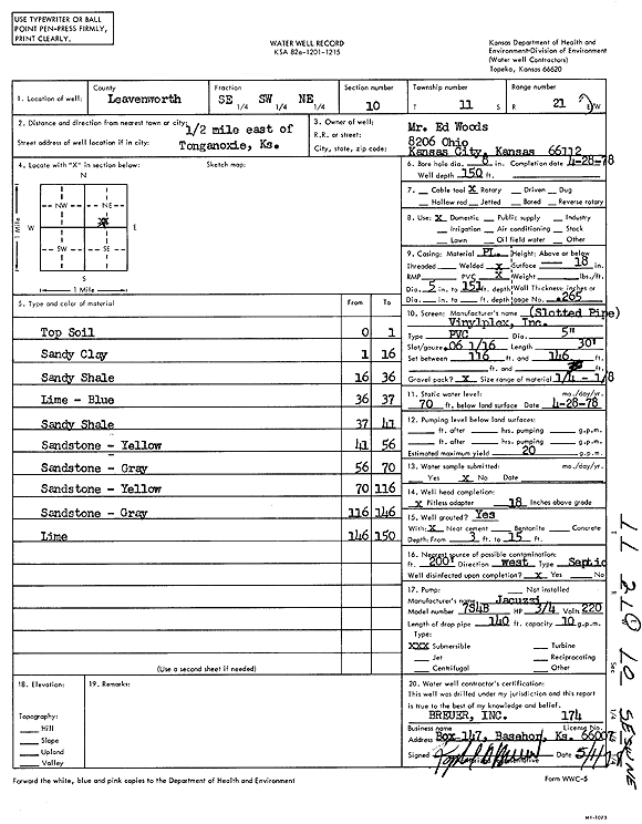
Specific Water Well Detail |
|
|
| Location Info | |||
| Owner: Woods, Ed | Status: Constructed | ||
| Location: T11S, R21E, Sec. 10, SE SW NE | County: Leavenworth | ||
| Directions: from Tonganoxie: .5 mi E | |||
| Latitude: 39.1100968 | Longitude: -95.0619253 | Datum NAD 27 | |
| Latitude: 39.1100987 | Longitude: -95.0621713 | Datum NAD 83 | |
| Longitude and latitude calculated by Survey from township-range-section-quarter calls. Only good to within the quarter call accuracy. | |||
| View well on interactive map | |||
| General Info | ||
| Well Depth: 150 ft. | Elevation: ft. | |
| Static Water Level: 70 ft. | Est. Yield: 20 gpm. | |
| Comp. Date: 28-Apr-1978 | Well Use: Domestic | |
| DWR Applic. #: | Other ID: | |
| Driller Info | ||
| Driller: Raphael Breuer, Inc. | License #: 174 | |
| Scanned Form | View scan |
|
Chemical Sample Submitted?: No
Water Well disinfected?: | ||
| Ground water encountered: 0 ft. , 0 ft. , 0 ft. | ||
| Pump test data: Well water was 0 ft after 0 hours pumping 0 gpm | ||
| Casing Info | ||
| Casing Type:
Casing Joints: |
Diam: 0 in. to 0 ft
Diam: 0 in. to 0 ft Diam: 0 in. to 0 ft | |
| Casing height above land surface: in
Casing Weight: lbs/ft Wall thickness or gauge no.: | ||
| Screen and Perforation Info | ||
| Screen Type: | Screen Openings: | |
| Screen-perforated intervals | From: 116 ft to 146 ft
From: 0 ft to 0 ft From: 0 ft to 0 ft | |
| Gravel pack intervals | From: ft to ft | |
| Grout Info | ||
| Grout used: | From: 0 to 0 ft
From: 0 to 0 ft From: 0 to 0 ft | |
| Source of Possible Contamination | ||
| Source: | ||
| Direction from well: | Distance: 0 ft | |
| Lithologic Log
(Log data entered by KGS.) | ||
| From: 0 ft. to 1 ft. | top soil | |
| From: 1 ft. to 16 ft. | sandy clay | |
| From: 16 ft. to 36 ft. | sandy shale | |
| From: 36 ft. to 37 ft. | limestone, blue | |
| From: 37 ft. to 41 ft. | sandy shale | |
| From: 41 ft. to 56 ft. | sandstone, yellow | |
| From: 56 ft. to 70 ft. | sandstone, gray | |
| From: 70 ft. to 116 ft. | sandstone, yellow | |
| From: 116 ft. to 146 ft. | sandstone, gray | |
| From: 146 ft. to 150 ft. | limestone | |