|
|
|
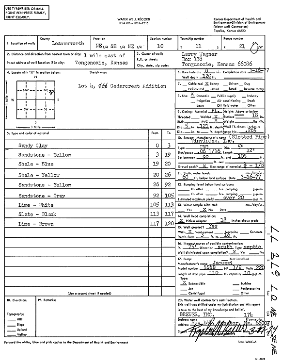
Specific Water Well Detail |
|
|
| Location Info | |||
| Owner: Wagner, Larry | Status: Constructed | ||
| Location: T11S, R21E, Sec. 10, NE SE NE | County: Leavenworth | ||
| Directions: from Tonganoxie: 1 mi E, lot 4 of Cedar Crest Addition | |||
| Latitude: 39.1118854 | Longitude: -95.0572792 | Datum NAD 27 | |
| Latitude: 39.1118874 | Longitude: -95.0575251 | Datum NAD 83 | |
| Longitude and latitude calculated by Survey from township-range-section-quarter calls. Only good to within the quarter call accuracy. | |||
| View well on interactive map | |||
| General Info | ||
| Well Depth: 120 ft. | Elevation: ft. | |
| Static Water Level: 60 ft. | Est. Yield: 20 gpm. | |
| Comp. Date: 16-Mar-1977 | Well Use: Domestic | |
| DWR Applic. #: | Other ID: | |
| Driller Info | ||
| Driller: Raphael Breuer, Inc. | License #: 174 | |
| Scanned Form | View scan |
|
Chemical Sample Submitted?: No
Water Well disinfected?: | ||
| Ground water encountered: 0 ft. , 0 ft. , 0 ft. | ||
| Pump test data: Well water was 0 ft after 0 hours pumping 0 gpm | ||
| Casing Info | ||
| Casing Type:
Casing Joints: |
Diam: 0 in. to 0 ft
Diam: 0 in. to 0 ft Diam: 0 in. to 0 ft | |
| Casing height above land surface: in
Casing Weight: lbs/ft Wall thickness or gauge no.: | ||
| Screen and Perforation Info | ||
| Screen Type: | Screen Openings: | |
| Screen-perforated intervals | From: 92 ft to 105 ft
From: 0 ft to 0 ft From: 0 ft to 0 ft | |
| Gravel pack intervals | From: ft to ft | |
| Grout Info | ||
| Grout used: | From: 0 to 0 ft
From: 0 to 0 ft From: 0 to 0 ft | |
| Source of Possible Contamination | ||
| Source: | ||
| Direction from well: | Distance: 0 ft | |
| Lithologic Log
(Log data entered by KGS.) | ||
| From: 0 ft. to 3 ft. | sandy clay | |
| From: 3 ft. to 19 ft. | sandstone, yellow | |
| From: 19 ft. to 20 ft. | shale, blue | |
| From: 20 ft. to 26 ft. | shale, yellow | |
| From: 26 ft. to 92 ft. | sandstone, yellow | |
| From: 92 ft. to 105 ft. | sandstone, gray | |
| From: 105 ft. to 113 ft. | limestone, white | |
| From: 113 ft. to 117 ft. | slate, black | |
| From: 117 ft. to 120 ft. | limestone, brown | |