|
|
|
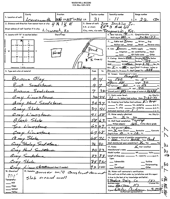
Specific Water Well Detail |
|
|
| Location Info | |||
| Owner: Jenkins Jr., Joe | Status: Constructed | ||
| Location: T11S, R22E, Sec. 31, NE NE NW | County: Leavenworth | ||
| Directions: from Linwood: 4 mi N, 1.5 mi E | |||
| Latitude: 39.0574045 | Longitude: -95.011192 | Datum NAD 27 | |
| Latitude: 39.0574075 | Longitude: -95.0114377 | Datum NAD 83 | |
| Longitude and latitude calculated by Survey from township-range-section-quarter calls. Only good to within the quarter call accuracy. | |||
| View well on interactive map | |||
| General Info | ||
| Well Depth: 100 ft. | Elevation: 900 ft. | |
| Static Water Level: 21 ft. | Est. Yield: 1 gpm. | |
| Comp. Date: 26-Jul-1977 | Well Use: Domestic | |
| DWR Applic. #: | Other ID: | |
| Driller Info | ||
| Driller: Strader Drilling Co., Inc. | License #: 182 | |
| Scanned Form | View scan |
|
Chemical Sample Submitted?: No
Water Well disinfected?: | ||
| Ground water encountered: 0 ft. , 0 ft. , 0 ft. | ||
| Pump test data: Well water was 0 ft after 0 hours pumping 0 gpm | ||
| Casing Info | ||
| Casing Type:
Casing Joints: |
Diam: 0 in. to 0 ft
Diam: 0 in. to 0 ft Diam: 0 in. to 0 ft | |
| Casing height above land surface: in
Casing Weight: lbs/ft Wall thickness or gauge no.: | ||
| Screen and Perforation Info | ||
| Screen Type: | Screen Openings: | |
| Screen-perforated intervals | From: 20 ft to 40 ft
From: 80 ft to 90 ft From: 0 ft to 0 ft | |
| Gravel pack intervals | From: ft to ft | |
| Grout Info | ||
| Grout used: | From: 0 to 0 ft
From: 0 to 0 ft From: 0 to 0 ft | |
| Source of Possible Contamination | ||
| Source: | ||
| Direction from well: | Distance: 0 ft | |
| Lithologic Log
(Log data entered by KGS.) | ||
| From: 0 ft. to 4 ft. | brown clay | |
| From: 4 ft. to 7 ft. | rust sandstone | |
| From: 7 ft. to 32 ft. | brown sandstone | |
| From: 32 ft. to 34 ft. | gray limestone | |
| From: 34 ft. to 37 ft. | gray hard sandstone | |
| From: 37 ft. to 41 ft. | gray shale | |
| From: 41 ft. to 58 ft. | gray limestone | |
| From: 58 ft. to 63 ft. | black shale | |
| From: 63 ft. to 67 ft. | tan limestone | |
| From: 67 ft. to 68 ft. | gray limestone | |
| From: 68 ft. to 76 ft. | gray shale | |
| From: 76 ft. to 80 ft. | gray shaley sandstone | |
| From: 80 ft. to 83 ft. | gray hard sandstone | |
| From: 83 ft. to 88 ft. | gray sandstone | |
| From: 88 ft. to 92 ft. | gray shale | |
| From: 92 ft. to 100 ft. | gray limestone | |