|
|
|
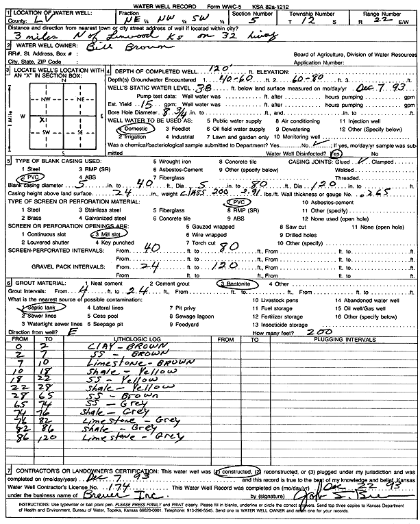
Specific Water Well Detail |
|
|
| Location Info | |||
| Owner: Brown, Bill | Status: Constructed | ||
| Location: T12S, R22E, Sec. 5, NE NW SW | County: Leavenworth | ||
| Directions: from Linwood: 3 mi N on 32 Hwy | |||
| Latitude: 39.0356305 | Longitude: -94.9979007 | Datum NAD 27 | |
| Latitude: 39.0356337 | Longitude: -94.9981464 | Datum NAD 83 | |
| Longitude and latitude calculated by Survey from township-range-section-quarter calls. Only good to within the quarter call accuracy. | |||
| View well on interactive map | |||
| General Info | ||
| Well Depth: 120 ft. | Elevation: ft. | |
| Static Water Level: 38 ft. | Est. Yield: 15 gpm. | |
| Comp. Date: 07-Dec-1993 | Well Use: Domestic | |
| DWR Applic. #: | Other ID: | |
| Driller Info | ||
| Driller: Raphael Breuer, Inc. | License #: 174 | |
| Scanned Form | View scan |
|
Chemical Sample Submitted?: No
Water Well disinfected?: | ||
| Ground water encountered: 60 ft. , 80 ft. , 0 ft. | ||
| Pump test data: Well water was 0 ft after 0 hours pumping 0 gpm | ||
| Casing Info | ||
| Casing Type: PVC
Casing Joints: |
Diam: 5 in. to 40 ft
Diam: 5 in. to 80 ft Diam: 5 in. to 120 ft | |
| Casing height above land surface: in
Casing Weight: lbs/ft Wall thickness or gauge no.: | ||
| Screen and Perforation Info | ||
| Screen Type: PVC | Screen Openings: Mill slot | |
| Screen-perforated intervals | From: 40 ft to 80 ft
From: 0 ft to 0 ft From: 0 ft to 0 ft | |
| Gravel pack intervals | From: ft to ft | |
| Grout Info | ||
| Grout used: Bentonite | From: 4 to 24 ft
From: 0 to 0 ft From: 0 to 0 ft | |
| Source of Possible Contamination | ||
| Source: Septic Tank | ||
| Direction from well: | Distance: 0 ft | |
| Lithologic Log
(Log data entered by KGS.) | ||
| From: 0 ft. to 2 ft. | clay, brown | |
| From: 2 ft. to 7 ft. | sandstone, brown | |
| From: 7 ft. to 10 ft. | limestone, brown | |
| From: 10 ft. to 18 ft. | shale, yellow | |
| From: 18 ft. to 22 ft. | sandstone, yellow | |
| From: 22 ft. to 28 ft. | shale, yellow | |
| From: 28 ft. to 65 ft. | sandstone, brown | |
| From: 65 ft. to 74 ft. | sandstone, gray | |
| From: 74 ft. to 76 ft. | shale, gray | |
| From: 76 ft. to 82 ft. | limestone, gray | |
| From: 82 ft. to 86 ft. | shale, gray | |
| From: 86 ft. to 120 ft. | limestone, gray | |