|
|
|
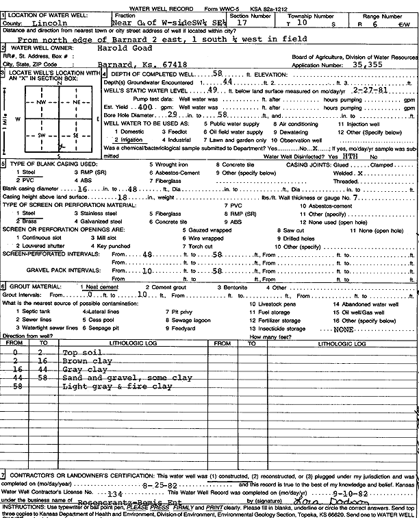
Specific Water Well Detail |
|
|
| Location Info | |||
| Owner: Goad, Harold | Status: Constructed | ||
| Location: T10S, R6W, Sec. 17, W2 SW SE | County: Lincoln | ||
| Directions: from north edge of Barnard, 2 mi E, 1 mi S, and 0.25 mi W in field | |||
| Latitude: 39.17692 | Longitude: -98.0122962 | Datum NAD 27 | |
| Latitude: 39.1769245 | Longitude: -98.01262 | Datum NAD 83 | |
| Longitude and latitude calculated by Survey from township-range-section-quarter calls. Only good to within the quarter call accuracy. | |||
| View well on interactive map | |||
| General Info | ||
| Well Depth: 58 ft. | Elevation: ft. | |
| Static Water Level: 49 ft. | Est. Yield: 400 gpm. | |
| Comp. Date: 25-Aug-1982 | Well Use: Irrigation | |
| DWR Applic. #: 35355 | Other ID: | |
| Links | |
| No Wizard information available. | |
| View info from WIMAS Water Right Data base... | |
| Driller Info | ||
| Driller: Rosencrantz-Bemis Enterprises, Inc. | License #: 134 | |
| Scanned Form | View scan |
|
Chemical Sample Submitted?: No
Water Well disinfected?: | ||
| Ground water encountered: 0 ft. , 0 ft. , 0 ft. | ||
| Pump test data: Well water was 0 ft after 0 hours pumping 0 gpm | ||
| Casing Info | ||
| Casing Type:
Casing Joints: |
Diam: 0 in. to 0 ft
Diam: 0 in. to 0 ft Diam: 0 in. to 0 ft | |
| Casing height above land surface: in
Casing Weight: lbs/ft Wall thickness or gauge no.: | ||
| Screen and Perforation Info | ||
| Screen Type: | Screen Openings: | |
| Screen-perforated intervals | From: 48 ft to 58 ft
From: 0 ft to 0 ft From: 0 ft to 0 ft | |
| Gravel pack intervals | From: ft to ft | |
| Grout Info | ||
| Grout used: | From: 0 to 0 ft
From: 0 to 0 ft From: 0 to 0 ft | |
| Source of Possible Contamination | ||
| Source: | ||
| Direction from well: | Distance: 0 ft | |
| Lithologic Log
(Log data entered by KGS.) | ||
| From: 0 ft. to 2 ft. | top soil | |
| From: 2 ft. to 16 ft. | brown clay | |
| From: 16 ft. to 44 ft. | gray clay | |
| From: 44 ft. to 58 ft. | sand and gravel, some clay | |
| From: 58 ft. to ft. | light gray and fire clay | |