|
|
|
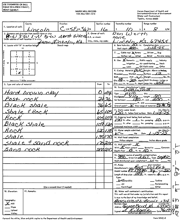
Specific Water Well Detail |
|
|
| Location Info | |||
| Owner: Werth, Don | Status: Constructed | ||
| Location: T10S, R8W, Sec. 16, C SE SW | County: Lincoln | ||
| Directions: from Lincoln, 8 mi N, 3 mi W, 1 mi N, 0.5 mi W, north side of road | |||
| Latitude: 39.177794 | Longitude: -98.2211163 | Datum NAD 27 | |
| Latitude: 39.177801 | Longitude: -98.2214483 | Datum NAD 83 | |
| Longitude and latitude calculated by Survey from township-range-section-quarter calls. Only good to within the quarter call accuracy. | |||
| View well on interactive map | |||
| General Info | ||
| Well Depth: 200 ft. | Elevation: ft. | |
| Static Water Level: 170 ft. | Est. Yield: gpm. | |
| Comp. Date: 15-Jan-1975 | Well Use: Domestic | |
| DWR Applic. #: | Other ID: | |
| Driller Info | ||
| Driller: Rosencrantz-Bemis Enterprises, Inc. | License #: 134 | |
| Scanned Form | View scan |
|
Chemical Sample Submitted?: Yes
Water Well disinfected?: | ||
| Ground water encountered: 0 ft. , 0 ft. , 0 ft. | ||
| Pump test data: Well water was 0 ft after 0 hours pumping 0 gpm | ||
| Casing Info | ||
| Casing Type:
Casing Joints: |
Diam: 0 in. to 0 ft
Diam: 0 in. to 0 ft Diam: 0 in. to 0 ft | |
| Casing height above land surface: in
Casing Weight: lbs/ft Wall thickness or gauge no.: | ||
| Screen and Perforation Info | ||
| Screen Type: | Screen Openings: | |
| Screen-perforated intervals | From: 180 ft to 200 ft
From: 0 ft to 0 ft From: 0 ft to 0 ft | |
| Gravel pack intervals | From: ft to ft | |
| Grout Info | ||
| Grout used: | From: 0 to 0 ft
From: 0 to 0 ft From: 0 to 0 ft | |
| Source of Possible Contamination | ||
| Source: | ||
| Direction from well: | Distance: 0 ft | |
| Lithologic Log
(Log data entered by KGS.) | ||
| From: 0 ft. to 24 ft. | hard brown clay | |
| From: 24 ft. to 36 ft. | Post Rock | |
| From: 36 ft. to 65 ft. | black shale | |
| From: 65 ft. to 105 ft. | shale and rock | |
| From: 105 ft. to 109 ft. | rock | |
| From: 109 ft. to 120 ft. | black shale | |
| From: 120 ft. to 135 ft. | rock | |
| From: 135 ft. to 170 ft. | shale | |
| From: 170 ft. to 200 ft. | shale and sand rock | |
| From: 200 ft. to 210 ft. | sand rock | |