|
|
|
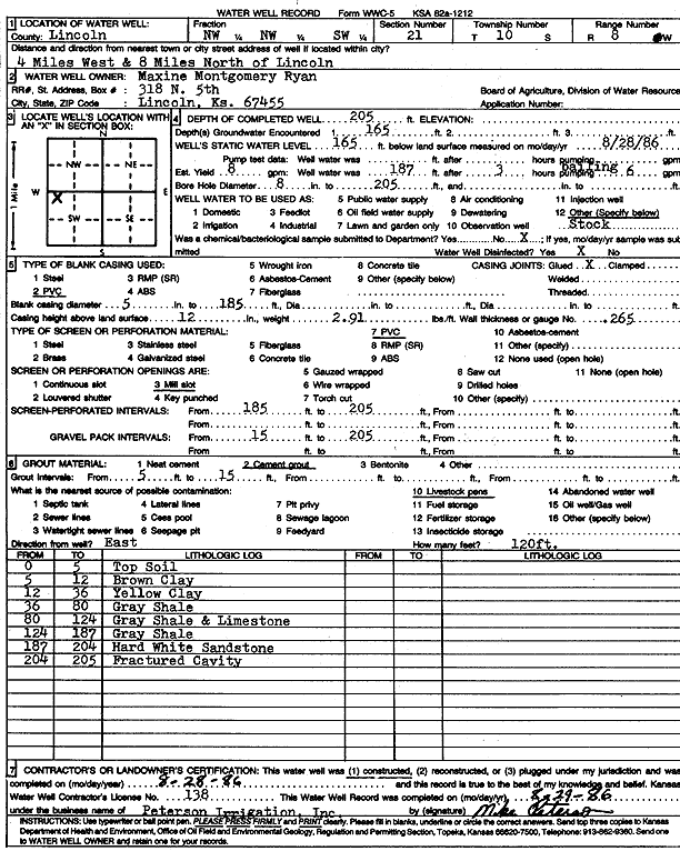
Specific Water Well Detail |
|
|
| Location Info | |||
| Owner: Ryan, Maxine Montgomery | Status: Constructed | ||
| Location: T10S, R8W, Sec. 21, NW NW SW | County: Lincoln | ||
| Directions: from Lincoln, 4 mi W and 8 mi N | |||
| Latitude: 39.1678297 | Longitude: -98.227016 | Datum NAD 27 | |
| Latitude: 39.1678367 | Longitude: -98.2273482 | Datum NAD 83 | |
| Longitude and latitude calculated by Survey from township-range-section-quarter calls. Only good to within the quarter call accuracy. | |||
| View well on interactive map | |||
| General Info | ||
| Well Depth: 205 ft. | Elevation: ft. | |
| Static Water Level: 165 ft. | Est. Yield: 8 gpm. | |
| Comp. Date: 28-Aug-1986 | Well Use: Domestic, Livestock | |
| DWR Applic. #: | Other ID: | |
| Driller Info | ||
| Driller: Michael Peterson Irrigation, Inc. | License #: 138 | |
| Scanned Form | View scan |
|
Chemical Sample Submitted?: No
Water Well disinfected?: | ||
| Ground water encountered: 165 ft. , 0 ft. , 0 ft. | ||
| Pump test data: Well water was 0 ft after 0 hours pumping 0 gpm | ||
| Casing Info | ||
| Casing Type: PVC
Casing Joints: |
Diam: 5 in. to 185 ft
Diam: 0 in. to 0 ft Diam: 0 in. to 0 ft | |
| Casing height above land surface: in
Casing Weight: lbs/ft Wall thickness or gauge no.: | ||
| Screen and Perforation Info | ||
| Screen Type: PVC | Screen Openings: Mill slot | |
| Screen-perforated intervals | From: 185 ft to 205 ft
From: 0 ft to 0 ft From: 0 ft to 0 ft | |
| Gravel pack intervals | From: ft to ft | |
| Grout Info | ||
| Grout used: Cement grout | From: 5 to 15 ft
From: 0 to 0 ft From: 0 to 0 ft | |
| Source of Possible Contamination | ||
| Source: Livestock pens | ||
| Direction from well: | Distance: 0 ft | |
| Lithologic Log
(Log data entered by KGS.) | ||
| From: 0 ft. to 5 ft. | top soil | |
| From: 5 ft. to 12 ft. | brown clay | |
| From: 12 ft. to 36 ft. | yellow clay | |
| From: 36 ft. to 80 ft. | gray shale | |
| From: 80 ft. to 124 ft. | gray shale and limestone | |
| From: 124 ft. to 187 ft. | gray shale | |
| From: 187 ft. to 204 ft. | hard white sandstone | |
| From: 204 ft. to 205 ft. | fractured cavity | |