|
|
|
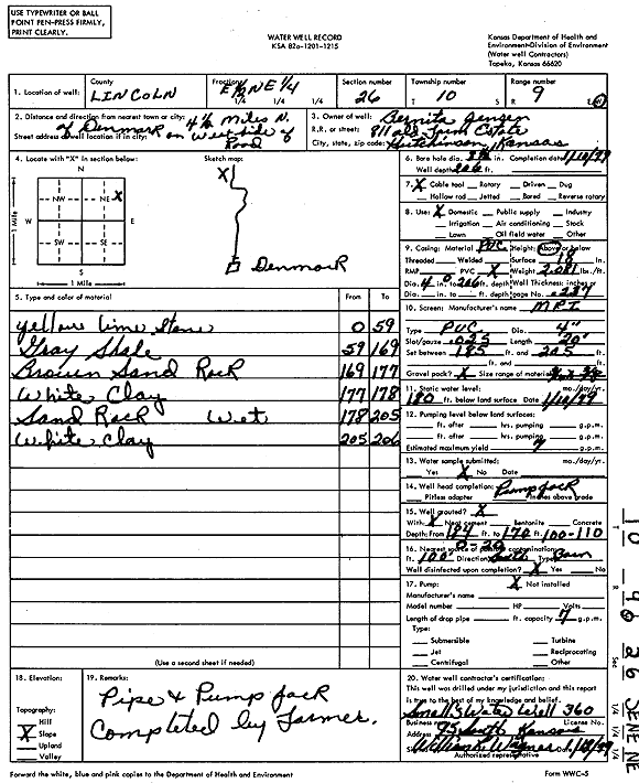
Specific Water Well Detail |
|
|
| Location Info | |||
| Owner: Jensen, Bernita | Status: Constructed | ||
| Location: T10S, R9W, Sec. 26, E2 NE | County: Lincoln | ||
| Directions: from Denmark, 4.5 mi N on west side of road | |||
| Latitude: 39.1576759 | Longitude: -98.2864966 | Datum NAD 27 | |
| Latitude: 39.1576836 | Longitude: -98.2868311 | Datum NAD 83 | |
| Longitude and latitude calculated by Survey from township-range-section-quarter calls. Only good to within the quarter call accuracy. | |||
| View well on interactive map | |||
| General Info | ||
| Well Depth: 206 ft. | Elevation: ft. | |
| Static Water Level: 180 ft. | Est. Yield: 7 gpm. | |
| Comp. Date: 10-Jan-1979 | Well Use: Domestic | |
| DWR Applic. #: | Other ID: | |
| Driller Info | ||
| Driller: Wagner Water Well Drlg | License #: 360 | |
| Scanned Form | View scan |
|
Chemical Sample Submitted?: No
Water Well disinfected?: | ||
| Ground water encountered: 0 ft. , 0 ft. , 0 ft. | ||
| Pump test data: Well water was 0 ft after 0 hours pumping 0 gpm | ||
| Casing Info | ||
| Casing Type:
Casing Joints: |
Diam: 0 in. to 0 ft
Diam: 0 in. to 0 ft Diam: 0 in. to 0 ft | |
| Casing height above land surface: in
Casing Weight: lbs/ft Wall thickness or gauge no.: | ||
| Screen and Perforation Info | ||
| Screen Type: | Screen Openings: | |
| Screen-perforated intervals | From: 185 ft to 205 ft
From: 0 ft to 0 ft From: 0 ft to 0 ft | |
| Gravel pack intervals | From: ft to ft | |
| Grout Info | ||
| Grout used: | From: 0 to 0 ft
From: 0 to 0 ft From: 0 to 0 ft | |
| Source of Possible Contamination | ||
| Source: | ||
| Direction from well: | Distance: 0 ft | |
| Lithologic Log
(Log data entered by KGS.) | ||
| From: 0 ft. to 59 ft. | yellow limestone | |
| From: 59 ft. to 169 ft. | gray shale | |
| From: 169 ft. to 177 ft. | brown sand rock | |
| From: 177 ft. to 178 ft. | white clay | |
| From: 178 ft. to 205 ft. | sand rock | |
| From: 205 ft. to 206 ft. | white clay | |