|
|
|
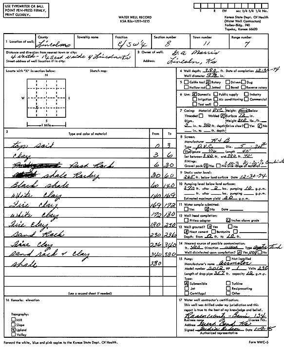
Specific Water Well Detail |
|
|
| Location Info | |||
| Owner: Morris, G.A. | Status: Constructed | ||
| Location: T11S, R7W, Sec. 8, C SW | County: Lincoln | ||
| Directions: from north side of Lincoln, 4 mi N and 1.25 mi E | |||
| Latitude: 39.1065761 | Longitude: -98.1277226 | Datum NAD 27 | |
| Latitude: 39.106582 | Longitude: -98.1280515 | Datum NAD 83 | |
| Longitude and latitude calculated by Survey from township-range-section-quarter calls. Only good to within the quarter call accuracy. | |||
| View well on interactive map | |||
| General Info | ||
| Well Depth: 380 ft. | Elevation: ft. | |
| Static Water Level: 265 ft. | Est. Yield: 20 gpm. | |
| Comp. Date: 30-Dec-1974 | Well Use: Domestic | |
| DWR Applic. #: | Other ID: | |
| Driller Info | ||
| Driller: Rosencrantz-Bemis Enterprises, Inc. | License #: 134 | |
| Scanned Form | View scan |
|
Chemical Sample Submitted?: No
Water Well disinfected?: | ||
| Ground water encountered: 0 ft. , 0 ft. , 0 ft. | ||
| Pump test data: Well water was 0 ft after 0 hours pumping 0 gpm | ||
| Casing Info | ||
| Casing Type:
Casing Joints: |
Diam: 0 in. to 0 ft
Diam: 0 in. to 0 ft Diam: 0 in. to 0 ft | |
| Casing height above land surface: in
Casing Weight: lbs/ft Wall thickness or gauge no.: | ||
| Screen and Perforation Info | ||
| Screen Type: | Screen Openings: | |
| Screen-perforated intervals | From: 340 ft to 380 ft
From: 0 ft to 0 ft From: 0 ft to 0 ft | |
| Gravel pack intervals | From: ft to ft | |
| Grout Info | ||
| Grout used: | From: 0 to 0 ft
From: 0 to 0 ft From: 0 to 0 ft | |
| Source of Possible Contamination | ||
| Source: | ||
| Direction from well: | Distance: 0 ft | |
| Lithologic Log
(Log data entered by KGS.) | ||
| From: 0 ft. to 3 ft. | top soil | |
| From: 3 ft. to 6 ft. | clay | |
| From: 6 ft. to 30 ft. | Post Rock | |
| From: 30 ft. to 60 ft. | shale, rocky | |
| From: 60 ft. to 140 ft. | black shale | |
| From: 140 ft. to 169 ft. | white clay | |
| From: 169 ft. to 172 ft. | fire clay | |
| From: 172 ft. to 180 ft. | white clay | |
| From: 180 ft. to 230 ft. | fire clay | |
| From: 230 ft. to 236 ft. | sand rock | |
| From: 236 ft. to 340 ft. | fire clay | |
| From: 340 ft. to 380 ft. | sand rock and clay | |
| From: 380 ft. to ft. | shale | |