|
|
|
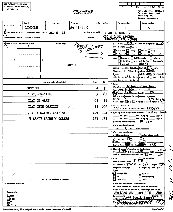
Specific Water Well Detail |
|
|
| Location Info | |||
| Owner: Nelson, Charles G. | Status: Constructed | ||
| Location: T11S, R7W, Sec. 11, S2 | County: Lincoln | ||
| Directions: from Lincoln, 2 mi E, 4 mi N, and 1 mi E | |||
| Latitude: 39.1067183 | Longitude: -98.0676921 | Datum NAD 27 | |
| Latitude: 39.1067236 | Longitude: -98.0680188 | Datum NAD 83 | |
| Longitude and latitude calculated by Survey from township-range-section-quarter calls. Only good to within the quarter call accuracy. | |||
| View well on interactive map | |||
| General Info | ||
| Well Depth: 133 ft. | Elevation: ft. | |
| Static Water Level: 110 ft. | Est. Yield: 10 gpm. | |
| Comp. Date: 15-Feb-1977 | Well Use: Domestic, Livestock | |
| DWR Applic. #: | Other ID: | |
| Driller Info | ||
| Driller: Small's Water Well Drlg & Serv. | License #: 260 | |
| Scanned Form | View scan |
|
Chemical Sample Submitted?: No
Water Well disinfected?: | ||
| Ground water encountered: 0 ft. , 0 ft. , 0 ft. | ||
| Pump test data: Well water was 0 ft after 0 hours pumping 0 gpm | ||
| Casing Info | ||
| Casing Type:
Casing Joints: |
Diam: 0 in. to 0 ft
Diam: 0 in. to 0 ft Diam: 0 in. to 0 ft | |
| Casing height above land surface: in
Casing Weight: lbs/ft Wall thickness or gauge no.: | ||
| Screen and Perforation Info | ||
| Screen Type: | Screen Openings: | |
| Screen-perforated intervals | From: 0 ft to 0 ft
From: 0 ft to 0 ft From: 0 ft to 0 ft | |
| Gravel pack intervals | From: ft to ft | |
| Grout Info | ||
| Grout used: | From: 0 to 0 ft
From: 0 to 0 ft From: 0 to 0 ft | |
| Source of Possible Contamination | ||
| Source: | ||
| Direction from well: | Distance: 0 ft | |
| Lithologic Log
(Log data entered by KGS.) | ||
| From: 0 ft. to 5 ft. | top soil | |
| From: 5 ft. to 85 ft. | clay, grayish | |
| From: 85 ft. to 95 ft. | clay, dark gray | |
| From: 95 ft. to 100 ft. | clay, light grayish | |
| From: 100 ft. to 123 ft. | clay, very sandy, grayish | |
| From: 123 ft. to 133 ft. | very sandy, brown, with cobbles | |