|
|
|
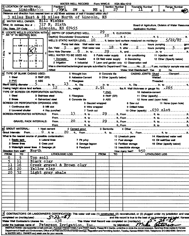
Specific Water Well Detail |
|
|
| Location Info | |||
| Owner: Wiebke, Bill | Status: Constructed | ||
| Location: T11S, R7W, Sec. 27, NW SW NE | County: Lincoln | ||
| Directions: from Lincoln, 3 mi E and 2.5 mi N | |||
| Latitude: 39.0694589 | Longitude: -98.0851827 | Datum NAD 27 | |
| Latitude: 39.0694645 | Longitude: -98.0855103 | Datum NAD 83 | |
| Longitude and latitude calculated by Survey from township-range-section-quarter calls. Only good to within the quarter call accuracy. | |||
| View well on interactive map | |||
| General Info | ||
| Well Depth: 29 ft. | Elevation: ft. | |
| Static Water Level: 10 ft. | Est. Yield: 5 gpm. | |
| Comp. Date: 22-May-1987 | Well Use: Domestic | |
| DWR Applic. #: | Other ID: | |
| Driller Info | ||
| Driller: Michael Peterson Irrigation, Inc. | License #: 138 | |
| Scanned Form | View scan |
|
Chemical Sample Submitted?: No
Water Well disinfected?: | ||
| Ground water encountered: 10 ft. , 0 ft. , 0 ft. | ||
| Pump test data: Well water was 0 ft after 0 hours pumping 0 gpm | ||
| Casing Info | ||
| Casing Type: PVC
Casing Joints: |
Diam: 5 in. to 13 ft
Diam: 0 in. to 0 ft Diam: 0 in. to 0 ft | |
| Casing height above land surface: in
Casing Weight: lbs/ft Wall thickness or gauge no.: | ||
| Screen and Perforation Info | ||
| Screen Type: PVC | Screen Openings: OTHER | |
| Screen-perforated intervals | From: 13 ft to 29 ft
From: 0 ft to 0 ft From: 0 ft to 0 ft | |
| Gravel pack intervals | From: ft to ft | |
| Grout Info | ||
| Grout used: Cement grout | From: 0 to 20 ft
From: 0 to 0 ft From: 0 to 0 ft | |
| Source of Possible Contamination | ||
| Source: Septic Tank | ||
| Direction from well: | Distance: 0 ft | |
| Lithologic Log
(Log data entered by KGS.) | ||
| From: 0 ft. to 5 ft. | top soil | |
| From: 5 ft. to 11 ft. | black clay | |
| From: 11 ft. to 16 ft. | creek gravel and brown clay | |
| From: 16 ft. to 20 ft. | yellow clay | |
| From: 20 ft. to 32 ft. | light gray shale | |