|
|
|
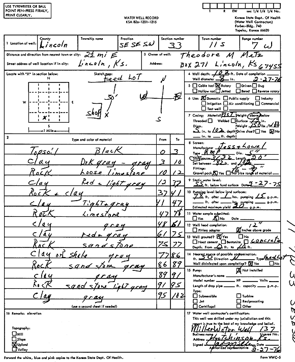
Specific Water Well Detail |
|
|
| Location Info | |||
| Owner: Metz, Theodore M. | Status: Constructed | ||
| Location: T11S, R7W, Sec. 33, SE SE SW | County: Lincoln | ||
| Directions: from Lincoln, 2.5 mi E | |||
| Latitude: 39.0458337 | Longitude: -98.1062297 | Datum NAD 27 | |
| Latitude: 39.0458396 | Longitude: -98.1065583 | Datum NAD 83 | |
| Longitude and latitude calculated by Survey from township-range-section-quarter calls. Only good to within the quarter call accuracy. | |||
| View well on interactive map | |||
| General Info | ||
| Well Depth: 102 ft. | Elevation: ft. | |
| Static Water Level: 55 ft. | Est. Yield: 20 gpm. | |
| Comp. Date: 27-Feb-1976 | Well Use: Domestic | |
| DWR Applic. #: | Other ID: | |
| Driller Info | ||
| Driller: Joseph M. Miller Water Well Service | License #: 137 | |
| Scanned Form | View scan |
|
Chemical Sample Submitted?: No
Water Well disinfected?: | ||
| Ground water encountered: 0 ft. , 0 ft. , 0 ft. | ||
| Pump test data: Well water was 0 ft after 0 hours pumping 0 gpm | ||
| Casing Info | ||
| Casing Type:
Casing Joints: |
Diam: 0 in. to 0 ft
Diam: 0 in. to 0 ft Diam: 0 in. to 0 ft | |
| Casing height above land surface: in
Casing Weight: lbs/ft Wall thickness or gauge no.: | ||
| Screen and Perforation Info | ||
| Screen Type: | Screen Openings: | |
| Screen-perforated intervals | From: 82 ft to 102 ft
From: 0 ft to 0 ft From: 0 ft to 0 ft | |
| Gravel pack intervals | From: ft to ft | |
| Grout Info | ||
| Grout used: | From: 0 to 0 ft
From: 0 to 0 ft From: 0 to 0 ft | |
| Source of Possible Contamination | ||
| Source: | ||
| Direction from well: | Distance: 0 ft | |
| Lithologic Log
(Log data entered by KGS.) | ||
| From: 0 ft. to 3 ft. | top soil, black | |
| From: 3 ft. to 10 ft. | clay, dark gray-gray | |
| From: 10 ft. to 12 ft. | rock, loose limestone | |
| From: 12 ft. to 37 ft. | clay, red and light gray | |
| From: 37 ft. to 41 ft. | rock and clay | |
| From: 41 ft. to 47 ft. | clay, tight, gray | |
| From: 47 ft. to 48 ft. | rock, limestone | |
| From: 48 ft. to 61 ft. | clay, gray | |
| From: 61 ft. to 75 ft. | clay, red and gray | |
| From: 75 ft. to 77 ft. | rock, sandstone | |
| From: 77 ft. to 86 ft. | clay or shale, gray | |
| From: 86 ft. to 89 ft. | rock, sandstone, gray | |
| From: 89 ft. to 91 ft. | clay, gray | |
| From: 91 ft. to 95 ft. | rock, sandstone, light gray | |
| From: 95 ft. to 102 ft. | clay, gray | |