|
|
|
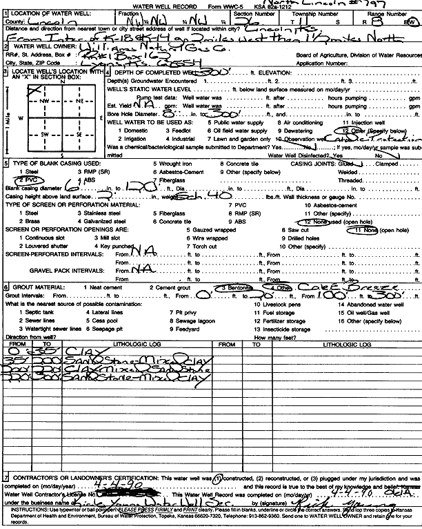
Specific Water Well Detail |
|
|
| Location Info | |||
| Owner: Williams Natural Gas Co. | Status: Constructed | ||
| Location: T11S, R8W, Sec. 26, NW NW NW | County: Lincoln | ||
| Directions: from K-18 and K-14, 2 mi W and 1.5 mi N (North Lincoln No. 797) | |||
| Latitude: 39.0731745 | Longitude: -98.1869333 | Datum NAD 27 | |
| Latitude: 39.073181 | Longitude: -98.1872645 | Datum NAD 83 | |
| Longitude and latitude calculated by Survey from township-range-section-quarter calls. Only good to within the quarter call accuracy. | |||
| View well on interactive map | |||
| General Info | ||
| Well Depth: 300 ft. | Elevation: ft. | |
| Static Water Level: ft. | Est. Yield: gpm. | |
| Comp. Date: 04-Apr-1990 | Well Use: Cathodic Protection Borehole | |
| DWR Applic. #: | Other ID: | |
| Driller Info | ||
| Driller: Rick Young Water Well Drlg. | License #: 584 | |
| Scanned Form | View scan |
|
Chemical Sample Submitted?: No
Water Well disinfected?: | ||
| Ground water encountered: 0 ft. , 0 ft. , 0 ft. | ||
| Pump test data: Well water was 0 ft after 0 hours pumping 0 gpm | ||
| Casing Info | ||
| Casing Type: PVC
Casing Joints: |
Diam: 6 in. to 120 ft
Diam: 0 in. to 0 ft Diam: 0 in. to 0 ft | |
| Casing height above land surface: in
Casing Weight: lbs/ft Wall thickness or gauge no.: | ||
| Screen and Perforation Info | ||
| Screen Type: None | Screen Openings: OTHER | |
| Screen-perforated intervals | From: 0 ft to 0 ft
From: 0 ft to 0 ft From: 0 ft to 0 ft | |
| Gravel pack intervals | From: ft to ft | |
| Grout Info | ||
| Grout used: Bentonite, | From: 0 to 20 ft
From: 100 to 300 ft From: 0 to 0 ft | |
| Source of Possible Contamination | ||
| Source: OTHER | ||
| Direction from well: | Distance: 0 ft | |
| Lithologic Log
(Log data entered by KGS.) | ||
| From: 0 ft. to 35 ft. | clay | |
| From: 35 ft. to 200 ft. | sandstone, mixed clay | |
| From: 200 ft. to 220 ft. | clay mixed with sandstone | |
| From: 220 ft. to 300 ft. | sandstone, mixed clay | |