|
|
|
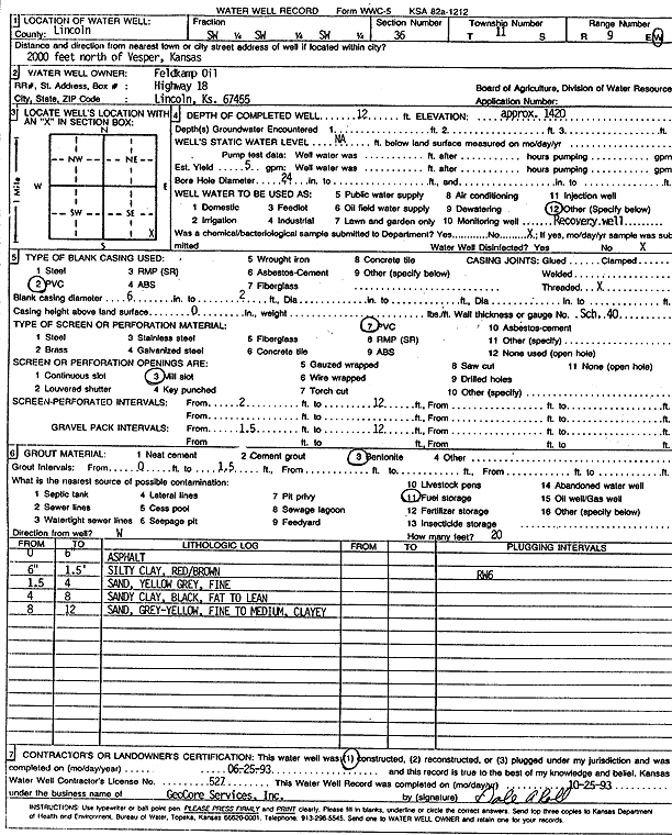
Specific Water Well Detail |
|
|
| Location Info | |||
| Owner: Feldkamp Oil | Status: Constructed | ||
| Location: T11S, R9W, Sec. 36, SW SW SW | County: Lincoln | ||
| Directions: from Vesper, 2000 feet N | |||
| Latitude: 39.0466605 | Longitude: -98.279066 | Datum NAD 27 | |
| Latitude: 39.0466682 | Longitude: -98.2794007 | Datum NAD 83 | |
| Longitude and latitude calculated by Survey from township-range-section-quarter calls. Only good to within the quarter call accuracy. | |||
| View well on interactive map | |||
| General Info | ||
| Well Depth: 12 ft. | Elevation: 1420 ft. | |
| Static Water Level: ft. | Est. Yield: 5 gpm. | |
| Comp. Date: 25-Jun-1993 | Well Use: Environmental Remediation, Recovery | |
| DWR Applic. #: | Other ID: RW 6 | |
| Driller Info | ||
| Driller: GeoCore Services Inc. | License #: 527 | |
| Scanned Form | View scan |
|
Chemical Sample Submitted?: No
Water Well disinfected?: | ||
| Ground water encountered: 0 ft. , 0 ft. , 0 ft. | ||
| Pump test data: Well water was 0 ft after 0 hours pumping 0 gpm | ||
| Casing Info | ||
| Casing Type: PVC
Casing Joints: |
Diam: 6 in. to 2 ft
Diam: 0 in. to 0 ft Diam: 0 in. to 0 ft | |
| Casing height above land surface: in
Casing Weight: lbs/ft Wall thickness or gauge no.: | ||
| Screen and Perforation Info | ||
| Screen Type: PVC | Screen Openings: Mill slot | |
| Screen-perforated intervals | From: 2 ft to 12 ft
From: 0 ft to 0 ft From: 0 ft to 0 ft | |
| Gravel pack intervals | From: ft to ft | |
| Grout Info | ||
| Grout used: Bentonite | From: 0 to 1 ft
From: 0 to 0 ft From: 0 to 0 ft | |
| Source of Possible Contamination | ||
| Source: Fuel storage | ||
| Direction from well: | Distance: 0 ft | |
| Lithologic Log
(Log data entered by KGS.) | ||
| From: 0 ft. to .5 ft. | asphalt | |
| From: .5 ft. to 1.5 ft. | silty clay, red brown | |
| From: 1.5 ft. to 4 ft. | sand, yellow gray, fine | |
| From: 4 ft. to 8 ft. | sandy clay, black, fat to lean | |
| From: 8 ft. to 12 ft. | sand, gray yellow, fine to medium, clayey | |